Eagles Point Buttress/Indian Staircase/Star Gap Arch
Just the Facts
Location: Red River Gorge Geological Area (Daniel Boon National Forest) - Slade, KY
General Rules and Regulations: Overnight permits are required (available at gas stations in Slade). No camping with 300' of a marked trail or road. No camping or fires within 100' of rock structures. Fires are permitted unless there s a fire ban in place - No cutting standing timber (dead or alive). Bear precautions are required.
Please see the USDA website, which is over Red River Gorge, for details on the rules.
Trip Highlights: 3 days/2 nights; temp ranged from mid 30s to low 60s
Menu: Oatmeal, Pasta & Meat Sauce, Mexican Chicken & Rice, Snacks
Shelter: Warbonnet Black Bird hammock, DIY JC Penney Under Quilt, Kelty Comsmic Down 20 Bag, Warbonnet Mamajamba Tarp
This was a bit of a spur of the moment trip. A friend and I saw the forecast and decided we couldn't pass up the opportunity to get out in February and not freeze! The warm weather would bring some unexpected challenges in that it melted most of the snow & ice, causing the Red River to claim more ground. Our goal was to check out a couple areas we hadn't been and scout another to get more familiar with it.
 Douglas Trail
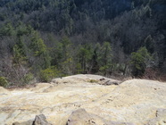
 Day 1: We started at the Osborne Bend trail head to hike to Eagles Point Buttress. The plan was to take the Douglas Trail to Eagles Point Buttress. We went as far as we could on the Douglas Trail before the Red River prevented any further progress. At the point where the river had claimed the trail as her own, we climbed up and bushwhacked our way until we could drop back down and proceed along the bank of the river. Before the trail left the river we filled up on water at a stream feeding the river (Eagles Point Buttress did have a small water source but, I'm not sure how reliable it would be). Back on the trail we made good time to reach Eagle Point Buttress where we enjoyed a view of the Red River from high above.
 Red River as seen from Eagles Point Buttress
 After taking in all the views we continued on unmarked trails toward the Osborne Bend trail. We stopped along the way and set up camp for the night. After dinner we warmed our thoughts by the fire before retiring to our hammocks. I remember the night sky being perfectly clear allowing the stars to light up the night sky.
Day 2: After some coffee and some oatmeal we pushed on toward the Osborne Bend trail. After navigating a few dead-fall sections we reached the intersection of Osborne Bend where we stopped for a light snack before heading toward the truck. We stopped at a rock bluff not far from the truck for another snack and some water before loading up to head to Indian Staircase.
Day 2: After some coffee and some oatmeal we pushed on toward the Osborne Bend trail. After navigating a few dead-fall sections we reached the intersection of Osborne Bend where we stopped for a light snack before heading toward the truck. We stopped at a rock bluff not far from the truck for another snack and some water before loading up to head to Indian Staircase.
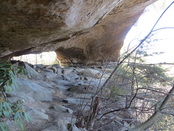
 Indian Staircase
 Back at the trail head we threw our gear in the truck and made the short drive to Bison Way trail head. We decided to day hike Indian Staircase so that we could make the assent up the staircase (if you are familiar with Indian Staircase you understand why this was a wise decision...Unless you have spidey senses or an unusual lack of fear of bodily harm). We took Bison Way to the Sheltowee where we shortly picked up the Indian Staircase trail. Moving upward we reached the base of the first scramble on the way to the top of Indian Staircase. After zig-zagging our way to the base of Indian Staircase we made the careful climb to the top (BTW - I have a VERY healthy fear of heights...Or, rather a fear of the possible results of heights). Once reaching the top we enjoyed conquering of fears (at least I did) and grand views offered up from our new vantage point. The price of admission was certainly worth it.
Since the trails we were traveling were all unmarked and had never previously taken them we decided not to enjoy too much time gawking over the God's handy work. We pressed on in search of the Indian Staircase Bypass trail to work our way back toward the Sheltowee. We worked our way around the ridge until we reached the end where we had to do some minor scrambles (the scrambles all become relative to what you have previously encountered...Indian Staircase for example) to come down off the ridge. After making our way back down to Sheltowee we realized why we didn't see the trail intersection of Sheltowee & Indian Staircase Bypass...It was mostly non existent, marked only by 3 scores on a tree. Not even the path was noticeable. We backtracked to the truck where we again moved on to new area.
Back on the road we headed to Tunnel Ridge Road where basically car camped at one of the parking areas. We set up camp and again stoked up a fire. We enjoyed the fire and another clear night full of stars before heading to the hammocks.
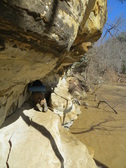
 Star Gap Arch
 Day 3: The next morning we headed toward Star Gap Arch for a little recon. We hiked the Star Gap Arch trail all the way to the end of the ridge while we looking possible future campsites along the way. After working our way around the ridges we began our return hike toward the arch, leaving some of the ridges and side trails for future visits.
We worked our way down to the arch where we enjoyed some snacks and water before doing some minor exploration around the arch. Again, leaving most of it for a return adventure. After several more pictures we once again headed back to the truck for another drive...This time back north to home.
We worked our way down to the arch where we enjoyed some snacks and water before doing some minor exploration around the arch. Again, leaving most of it for a return adventure. After several more pictures we once again headed back to the truck for another drive...This time back north to home.
 RSS Feed
