I Like Turtles - Turtles Need Water
Just the Facts
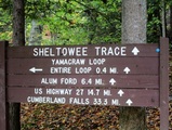
Location: Sheltowee Trace - Daniel Boone National Forest, KY
General Rules and Regulations: Camping is not allowed in the developed areas. Camping is allowed near the developed parking areas when the campsite is at least 200 feet from the edge of the parking area and IS NOT VISIBLE from the parking area. As of May 1, 1991, the following are considered developed areas: Yahoo Falls, Alum Ford, Yamacraw, Blue Heron Overlooks, Blue Heron and access areas along river, East Rim Overlook, Leatherwood Ford, West Entrance, Charit Creek, Twin Arches, Burnt Mill Bridge, Peters Bridge, Bear Creek Overlook, Brewster Bridge, and Honey Creek Overlook.
Camping is strictly prohibited within 25 feet of any cave, cemetery, grave site, historic site/structure, rock shelter, rim of the gorge, trail, roadway, or any other specified location identified by a "No Camping" sign.
Campfires are allowed unless condition dictate otherwise.
Backcountry permits are required within the Big South Fork (not required in the Daniel Boone National Forest in this section).
See the National Park Service website for more details.
Trip Highlights: 2 days/1 night; temps ranged from low 50s to upper 80s; approximately 15 miles. The trees were changing but, not peak color.
Shelter: Warbonnet Black Bird hammock, Hammock Gear under quilt & Underground Quilts top quilt, Warbonnet Mamajamba Tarp w/DIY Door Kit
Wildlife: Garter snake, squirrels, toads & turkey
Miscellaneous: http://www.sheltoweetrace.org/ http://www.ccl-bsf.com/
The Sheltowee Trace is Kentucky's long trail. The southern terminus has moved farther south a few times and is currently at the Burnt Mill Bridge in Allardt, TN. The trail runs 319 miles to the northern terminus located off KY 377 at the northern end of the Daniel Boone National Forest (north of Morehead, KY).
The returning cast would be Kyle & myself. We both drove to Kyle’s aunt & uncle, now AKA “Spark Outfitters”, the night before where we would stage and be shuttled to & fro. We are very fortunate to have family that we can stay with and be dropped off and picked up. Once more we were treated like royalty, I guess it pays to travel with a King!
We had four days planned for this section and hoped to make it to Cumberland Falls or Laurel Lake. But, we wanted to keep the trip relaxed. The forecast was unseasonably warm weather the first two days and then back to normal with one day/night of rain.
We had four days planned for this section and hoped to make it to Cumberland Falls or Laurel Lake. But, we wanted to keep the trip relaxed. The forecast was unseasonably warm weather the first two days and then back to normal with one day/night of rain.
Day 1 (Wed):
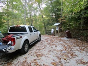
After a hardy breakfast prepared by “Spark Outfitters” we were ready for a short drive to Yamacraw to pick up where we left off last year. We came out last year at the bridge in Yamacraw so it was an easy place to start back. Bobby didn’t have any nuggets of wisdom this time other than to be careful eating gravy before hitting the trail...Too late, the system has already been lubed!
After a hardy breakfast prepared by “Spark Outfitters” we were ready for a short drive to Yamacraw to pick up where we left off last year. We came out last year at the bridge in Yamacraw so it was an easy place to start back. Bobby didn’t have any nuggets of wisdom this time other than to be careful eating gravy before hitting the trail...Too late, the system has already been lubed!
We got on the trail around 9:40 AM heading north with our sights set on Cumberland Falls. Out of Yamacraw the trail parallels the Cumberland River, winding its way north. We noticed the river was way down, probably 20 – 30 feet. At this point the realization of what the low water meant hadn’t set in.
Our goal for the day was to stop somewhere between Yahoo Falls and US-27. Along the way we planned to come off the Sheltowee to go past Markers Arch, Yahoo Arch and Yahoo Falls. But, our first stop would be Princess Falls on Lick Creek. The falls wasn’t much to look at with the current water levels. I think the only reason it had water is that Lick Creek is to be fed by a spring. None the less, it was worth the short walk to see. In hindsight we should have cameled up on water – more on this later.
Our goal for the day was to stop somewhere between Yahoo Falls and US-27. Along the way we planned to come off the Sheltowee to go past Markers Arch, Yahoo Arch and Yahoo Falls. But, our first stop would be Princess Falls on Lick Creek. The falls wasn’t much to look at with the current water levels. I think the only reason it had water is that Lick Creek is to be fed by a spring. None the less, it was worth the short walk to see. In hindsight we should have cameled up on water – more on this later.
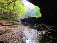 Princess Falls
 We returned to the Sheltowee where we retrieved our packs that we had dropped for the hike to Princess Falls. About another mile and a half and we would make it to Negro Creek. After crossing Negro Creek we took trail 612 toward KY-700. After crossing KY-700 the trail turns to 602 and we dropped our packs again to hike out to Markers Arch where we had lunch. The lunch menu today was smoked salmon on crackers with cream cheese and capers – Yep we went high class for the first day! By this point we realized that water was going to be an issue. Planning the trip we had looked at the map and Sheltowee Trace guide and knew the trail pretty much ran along streams and crossed streams most of the route. Turns out that once we left the river most everything was dry. And, accessing the river was no easy task due to the low water and mud - not my first choice for water anyway. As luck would have it, Lick Creek would be our last opportunity at flowing water until we crossed Big Creek, which was barely a trickle. We figured we would have reliable water at Yahoo Falls and would fill up there.
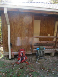 Yahoo Falls Trailhead
 After lunch we returned to Trail 602 and headed to Yahoo Arch and then on to Yahoo Falls. To our disappointment there was no falls as it was dry too. After hiking in the upper 80s we were looking forward to washing off in the falls and drinking up all we could. We came across the top of the falls, or what should be the falls, and could see it was dry. We didn’t even bother walking to the base of the falls and continued on to the parking lot where we found our first real water source – the bathroom sink. We asked two visitors if they had water but, no luck. One person offered to take one of us (not both) to town if it wasn’t so far (about 4 miles). Another was kind enough to inform us that it was only 4 miles to town (I nearly blurted out that there was no way we were walking 8 miles round trip). We tried to rehydrate and had some snacks before continuing on to drop back on the Sheltowee.
Back on the Sheltowee we were again following the Cumberland River north where we would leave the Big South Fork and enter the Daniel Boone National Forest. When we hit Big Creek we headed east away from the river and toward US-27. As we hiked along Big Creek we started looking for a suitable campsite while also looking for a decent water source. We each left Yahoo Falls trailhead with about two liters of water so, it wasn’t urgent. But, we were concerned about the next day as we would not be back on the river for at least a day and a half. And, with all the streams being dried we had real concerns about being able to get enough water to cook with and stay hydrated.
Back on the Sheltowee we were again following the Cumberland River north where we would leave the Big South Fork and enter the Daniel Boone National Forest. When we hit Big Creek we headed east away from the river and toward US-27. As we hiked along Big Creek we started looking for a suitable campsite while also looking for a decent water source. We each left Yahoo Falls trailhead with about two liters of water so, it wasn’t urgent. But, we were concerned about the next day as we would not be back on the river for at least a day and a half. And, with all the streams being dried we had real concerns about being able to get enough water to cook with and stay hydrated.
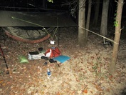 Camp
Camp We found a nice campsite not long after crossing Big Creek and set up camp there. After hanging our tarps and hammocks we were ready for dinner. Fortunately, we had another no cook meal of summer sausage, cheese & crackers. After dinner we relaxed for a while before building a very small fire to make s’mores. After dessert we hung our food bags and discussed our water situation. We pretty much decided that it was best to come off the trail at US-27 due to lack of water. We retired to our hammocks to rest up for the roughly four mile hike to Flat Rock Church where we would call for “Spark Outfitters” to pick us up.
Day 2 (Thu):
The last forecast we saw called for rain starting this morning and lasting through the night. But, the sky looked clear. We broke camp and I fixed a cup of coffee and had a breakfast bar (not enough water for oatmeal). Shortly after starting out we passed the private cabin along the trail. With only about 4 miles to extraction we weren't overly concerned with our water situation and thankfully so as the only water we saw was stagnant pools and water coming out of what looked to be a mined area or cave, either way it was likely full of sulfur and iron – not what you want to be drinking.
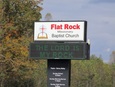
We made it to Flat Rock Church around Noon and made the call to Bobby to pick us up and take us to get some lunch, and a milkshake!
We spent the rest of our trip doing some day hikes and exploring McCeary County - Natural Arch, Split Bow Arch, Dry Fork Overlook, Devil's Jump, Barthell Mine...
The last forecast we saw called for rain starting this morning and lasting through the night. But, the sky looked clear. We broke camp and I fixed a cup of coffee and had a breakfast bar (not enough water for oatmeal). Shortly after starting out we passed the private cabin along the trail. With only about 4 miles to extraction we weren't overly concerned with our water situation and thankfully so as the only water we saw was stagnant pools and water coming out of what looked to be a mined area or cave, either way it was likely full of sulfur and iron – not what you want to be drinking.
We made it to Flat Rock Church around Noon and made the call to Bobby to pick us up and take us to get some lunch, and a milkshake!
We spent the rest of our trip doing some day hikes and exploring McCeary County - Natural Arch, Split Bow Arch, Dry Fork Overlook, Devil's Jump, Barthell Mine...
Summary: Obviously, our trip did not go as planned. We learned that the area hadn’t had rain in quite a while and was basically in a drought. We never thought water would be an issue, on most all of the Sheltowee, because most of the time it runs along streams and/or crosses streams on much of the route. However, even the “reliable” water sources were dried up. We just weren’t prepared for the lack of water and didn’t plan for needing to carrying the amount of water that would be necessary for the dry conditions. While this hunt for the Big Turtle was a bit of a bust, we were still able to enjoy the woods.
I like turtles!
Honorable Mentions: I switched up my tarp guy lines by changing over from braided mason’s line to Kelty Triptease cordage. While at it I added a couple feet to the lines making them eight feet long. The Triptease line has a reflective material weaved in and is much easier to work with since it is 1.5 mm line. The larger diameter and length made it easier to use a McCarthy Hitch and knots. Overall, a win for the marginal difference in weight.
Honorably Discharged: Luxury food – the smoked salmon was great and a big boost in calories but, it’s too much work and weight for backpacking. I’ll reserve this meal for car camping.
Dishonorably Discharged: Again, nothing was an outright fail. My kit is pretty well lined out at this point aside from the occasional experiment or new item.
 RSS Feed
