Hot & Cold
Just the Facts
Location: Sheltowee Trace - Daniel Boone National Forest, KY
General Rules and Regulations: Camping is not allowed in the developed areas. Camping is allowed near the developed parking areas when the campsite is at least 200 feet from the edge of the parking area and IS NOT VISIBLE from the parking area. As of May 1, 1991, the following are considered developed areas: Yahoo Falls, Alum Ford, Yamacraw, Blue Heron Overlooks, Blue Heron and access areas along river, East Rim Overlook, Leatherwood Ford, West Entrance, Charit Creek, Twin Arches, Burnt Mill Bridge, Peters Bridge, Bear Creek Overlook, Brewster Bridge, and Honey Creek Overlook.
Camping is strictly prohibited within 25 feet of any cave, cemetery, grave site, historic site/structure, rock shelter, rim of the gorge, trail, roadway, or any other specified location identified by a "No Camping" sign.
Campfires are allowed unless condition dictate otherwise.
Backcountry permits are required within the Big South Fork (not required in the Daniel Boone National Forest in this section).
See the National Park Service website for more details.
Trip Highlights: 7 days; temps ranged from low 20s to upper 70s; approximately 67 miles. Spring flowers and several of water falls & cascades.
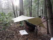
Shelter: Warbonnet Black Bird hammock, Hammock Gear Underquilt, Underground Quilts top quilt, Warbonnet Mamajamba Tarp w/DIY Door Kit
Wildlife: Various waterfowl, hawks, buzzards, turkeys, squirrels, chipmunks, whitetail deer and fish.
Miscellaneous: http://www.sheltoweetrace.org/
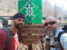
The Sheltowee Trace is Kentucky's long trail. The southern terminus has moved farther south a few times and is currently at the Burnt Mill Bridge in Allardt, TN. The trail runs 323 miles to the northern terminus located off KY 377 at the northern end of the Daniel Boone National Forest (north of Morehead, KY).
The extended forecast leading up to this trip showed temps dipping down to the low 20's when we planned to put in on Saturday and up near 80 for the high before we planned to come out on the following Saturday.. It also showed a chance of rain every day. This all combined to make preparing for the trip challenging. Even after having to pack for 2 seasons in a week I felt like my pack weight was pretty good (which I never weighed) until I added 8 days worth of food.
Once again we had the luxury of of staying with Kyle's aunt and uncle at the "Barn & Bunk B&B" Friday night. Hard to ask for better hospitality! Of course I stopped at Milton's and picked up a couple of peanut butter fudge milkshakes to have after dinner at the Dairy Bar.
Location: Sheltowee Trace - Daniel Boone National Forest, KY
General Rules and Regulations: Camping is not allowed in the developed areas. Camping is allowed near the developed parking areas when the campsite is at least 200 feet from the edge of the parking area and IS NOT VISIBLE from the parking area. As of May 1, 1991, the following are considered developed areas: Yahoo Falls, Alum Ford, Yamacraw, Blue Heron Overlooks, Blue Heron and access areas along river, East Rim Overlook, Leatherwood Ford, West Entrance, Charit Creek, Twin Arches, Burnt Mill Bridge, Peters Bridge, Bear Creek Overlook, Brewster Bridge, and Honey Creek Overlook.
Camping is strictly prohibited within 25 feet of any cave, cemetery, grave site, historic site/structure, rock shelter, rim of the gorge, trail, roadway, or any other specified location identified by a "No Camping" sign.
Campfires are allowed unless condition dictate otherwise.
Backcountry permits are required within the Big South Fork (not required in the Daniel Boone National Forest in this section).
See the National Park Service website for more details.
Trip Highlights: 7 days; temps ranged from low 20s to upper 70s; approximately 67 miles. Spring flowers and several of water falls & cascades.
Shelter: Warbonnet Black Bird hammock, Hammock Gear Underquilt, Underground Quilts top quilt, Warbonnet Mamajamba Tarp w/DIY Door Kit
Wildlife: Various waterfowl, hawks, buzzards, turkeys, squirrels, chipmunks, whitetail deer and fish.
Miscellaneous: http://www.sheltoweetrace.org/
The Sheltowee Trace is Kentucky's long trail. The southern terminus has moved farther south a few times and is currently at the Burnt Mill Bridge in Allardt, TN. The trail runs 323 miles to the northern terminus located off KY 377 at the northern end of the Daniel Boone National Forest (north of Morehead, KY).
The extended forecast leading up to this trip showed temps dipping down to the low 20's when we planned to put in on Saturday and up near 80 for the high before we planned to come out on the following Saturday.. It also showed a chance of rain every day. This all combined to make preparing for the trip challenging. Even after having to pack for 2 seasons in a week I felt like my pack weight was pretty good (which I never weighed) until I added 8 days worth of food.
Once again we had the luxury of of staying with Kyle's aunt and uncle at the "Barn & Bunk B&B" Friday night. Hard to ask for better hospitality! Of course I stopped at Milton's and picked up a couple of peanut butter fudge milkshakes to have after dinner at the Dairy Bar.
Day 1 (Sat):
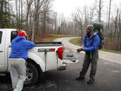
It was cold and we weren't in a hurry to get started. We were hoping it may warm up but, I think the temperature may have topped out before Noon. We had breakfast and loaded our gear in the truck to be dropped off where the trail crosses KY-700 at Catron Rd. I think Bobby dropped us off around 12:30 PM with temps in the low to mid 30's and light flurries. I don't recall Bobby bestowing any wisdom upon us...It was likely just over my head. Our plan for the day would be to make it somewhere around Cumberland Falls for a 10 mile day.
We headed north toward the falls and quickly ran into Billy, AKA Shutterbug, who was doing the STA Flip/Flop hike with his dogs. Billy and his pack had started that morning at Cumberland Falls. We parted ways with Billy and soon popped back out on KY-700 for a pretty good road walk. We stopped at Indian Creek for a break and some fuel before making the climb up KY-700. We made the turn onto Thunderstruck Rd. with our best (or worst) AC/DC rendition as we headed down to the Cumberland River and back on trail.
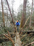
Back on the trail we ran into several blow downs. For some reason the Hemlocks had taken a recent beating - There were several down between Thunderstruck Rd. and Bark Camp Creek.
We walked along the river until we came out on KY-90. Along the way we passed some old timers' camp set up for the long haul complete with a portalet. And, we got a glimpse at how despicable humans are with all the trash washed up from high water.
We crossed the Edward M. Gatliff Memorial Bridge and headed toward the gift shop and falls. We had dinner at the tables finishing up a bit after 7:00 PM. We would need to hike about another 2 miles to get out of the state park and be allowed to camp. With darkness looming and the temp dropping we decided to get a room at the Dupont Lodge. We checked in, Kyle provided the vehicle information with Salomons size 12, and we went to our room for hot showers and crashed for the night.
Day 2 (Sun):
We left the lodge around 9:30 AM after having an omelette, pancakes and my last hot coffee for the week (EEK!). We spent a while viewing the falls and talking to a guy that had ran the Yamacraw trail race (20K) Saturday.
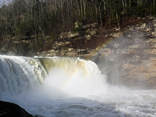
Cumberland Falls is known as the Niagara of the South. It is a 68 ft tall water fall and is well known as one of the few places to consistently view a moonbow - All the times I've been I've never witnessed a moonbow.
The trail leaving the falls continues along the river to Bark Camp Creek. There were a lot of people on the river fishing. I would have thought the water would be pretty murky and swift. But, our guess was that the higher water allowed boats to get places they normally couldn't reach.
We left the lodge around 9:30 AM after having an omelette, pancakes and my last hot coffee for the week (EEK!). We spent a while viewing the falls and talking to a guy that had ran the Yamacraw trail race (20K) Saturday.
Cumberland Falls is known as the Niagara of the South. It is a 68 ft tall water fall and is well known as one of the few places to consistently view a moonbow - All the times I've been I've never witnessed a moonbow.
The trail leaving the falls continues along the river to Bark Camp Creek. There were a lot of people on the river fishing. I would have thought the water would be pretty murky and swift. But, our guess was that the higher water allowed boats to get places they normally couldn't reach.
We stopped at the Star Creek shelter for a break and a snack before moving on toward Dog Slaughter Falls. We hiked to the falls and back to the foot bridge where we had lunch. After lunch we moved on to the Bark Camp Creek shelter where we took another break and got more fuel. The trail continues up Bark Camp Creek to a newer bridge and then back down the creek. When we got to the high water route we decided to play it safe and fill up on water to take the high water route.
We took the high road because we weren't sure if the trail would be flooded and we knew the water level was up from what we'd hiked thus far. The trail between Cumberland Falls and Bark Camp Creek is also pretty technical with lots of roots and rocks and our feet were happy to get off that. We climbed up on the ridge and found a spot to set up camp and called it a day.
We took the high road because we weren't sure if the trail would be flooded and we knew the water level was up from what we'd hiked thus far. The trail between Cumberland Falls and Bark Camp Creek is also pretty technical with lots of roots and rocks and our feet were happy to get off that. We climbed up on the ridge and found a spot to set up camp and called it a day.
Day 3 (Mon):
Rain moved in over night and continued into the morning. We were in no hurry to come out of the warmth of our hammocks so we slept in hoping to wait out the rain. The rain stopped a little after 8:00 AM so we left the downy goodness of home for the night and began packing up wet tarps to head off toward Laurel Lake.
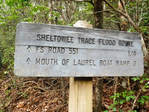
The trail down to the Mouth of the Laurel was a steep and slippery route. After the high water route rejoins the main route there's a short road walk past the boat ramp. We stopped at the privy to take care of the the necessities, have breakfast and drop our trash.
The foot massager (rocks) was back on until we got to the dam. We stopped at the pavilion to have lunch and dry out our tarps. After a long lunch and good breeze our tarps were dry and ready for deployment.
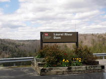
Laurel River Dam was built in 1964 to 1974 by the U.S. Army Corps of Engineers for hydroelectricity. According to Wiki it produces 67 gigawatt hours of hydroelectricity. The reservoir is also developed for various recreational activities.
My feet were barking and I was ready to call it an early day. We agreed to stop a bit early and set up camp at the campground. When we got to the campground around 5:30 PM we found out it was still closed. I checked the marina's website before we left and knew it was closed. But, I thought the campground was open. I was wrong. So, we pushed on in search of a place to camp. We eventually found a good spot after we walked the lake and started to head away from the water.
The trail around the lake is a shared use trail with mountain bikers. I think that's why it was groomed so well making it relatively easy walking.
Rain moved in over night and continued into the morning. We were in no hurry to come out of the warmth of our hammocks so we slept in hoping to wait out the rain. The rain stopped a little after 8:00 AM so we left the downy goodness of home for the night and began packing up wet tarps to head off toward Laurel Lake.
The trail down to the Mouth of the Laurel was a steep and slippery route. After the high water route rejoins the main route there's a short road walk past the boat ramp. We stopped at the privy to take care of the the necessities, have breakfast and drop our trash.
The foot massager (rocks) was back on until we got to the dam. We stopped at the pavilion to have lunch and dry out our tarps. After a long lunch and good breeze our tarps were dry and ready for deployment.
Laurel River Dam was built in 1964 to 1974 by the U.S. Army Corps of Engineers for hydroelectricity. According to Wiki it produces 67 gigawatt hours of hydroelectricity. The reservoir is also developed for various recreational activities.
My feet were barking and I was ready to call it an early day. We agreed to stop a bit early and set up camp at the campground. When we got to the campground around 5:30 PM we found out it was still closed. I checked the marina's website before we left and knew it was closed. But, I thought the campground was open. I was wrong. So, we pushed on in search of a place to camp. We eventually found a good spot after we walked the lake and started to head away from the water.
The trail around the lake is a shared use trail with mountain bikers. I think that's why it was groomed so well making it relatively easy walking.
Day 4 (Tue):
I thought this was the prettiest day of this section. We saw several waterfalls and cascades as we hiked along and through various streams.
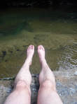
We took a long break at the wooden bridge over Cane Creek to soak our feet & legs in the cold water and soak up some sun. The water was ice cold and felt great on our feet but, it was so cold we couldn't stay in or take much more than up to our knees. Even though we didn't get to bathe our stinky bodies we did get to sun bathe!
We continued on to Van Hook Falls where we had lunch and then onward toward KY-80. We passed a southbound thru-hiker, Mad Hat from northern MN, who had put in the first day of Spring at the northern terminus. He had endured some pretty crazy weather with snow, flooding and cold temps. But, he was in good spirits and seemed pretty gritty.
We set up camp on a knob a few miles south of KY-80. It was pretty windy so we battened down the hatches to block the wind and stay warm. Once the sun went down the wind died down and it was a pretty calm night. We had small campfire to sit around and relax before going to bed. We studied the map & guide book and figured we'd make it to KY-490 by Friday. at our current pace.
I thought this was the prettiest day of this section. We saw several waterfalls and cascades as we hiked along and through various streams.
We took a long break at the wooden bridge over Cane Creek to soak our feet & legs in the cold water and soak up some sun. The water was ice cold and felt great on our feet but, it was so cold we couldn't stay in or take much more than up to our knees. Even though we didn't get to bathe our stinky bodies we did get to sun bathe!
We continued on to Van Hook Falls where we had lunch and then onward toward KY-80. We passed a southbound thru-hiker, Mad Hat from northern MN, who had put in the first day of Spring at the northern terminus. He had endured some pretty crazy weather with snow, flooding and cold temps. But, he was in good spirits and seemed pretty gritty.
We set up camp on a knob a few miles south of KY-80. It was pretty windy so we battened down the hatches to block the wind and stay warm. Once the sun went down the wind died down and it was a pretty calm night. We had small campfire to sit around and relax before going to bed. We studied the map & guide book and figured we'd make it to KY-490 by Friday. at our current pace.
Day 5 (Wed):
We crossed KY-80 and 2 suspension bridges today as we we closed in on I-75. We were now motivated by a goal to get a big greasy cheeseburger at the truck stop at I-75 for lunch tomorrow.
The scenery was pretty on the north side of KY-80 and looked to be the last significant amount of trail for the rest of this section.
We ended up setting up camp at the suspension bridge a few miles short of Livingston. It was a pretty cool campsite full of Mountain Laurel between a rock wall and a stream. We had another small fire for Kyle to dry and melt his boots, and the fingerprints off my finger, before crashing.
Day 5 (Thu):
We had about 5 miles between us and a cheeseburger. After a quick breakfast and filtering some water we were off for a cheeseburger! We made it to the 49er truck stop around Noon and ordered some cheeseburgers and a couple Ale 8 Ones to enjoy a meal that wasn't dehydrated. After lunch it was time for some ice cream and fluids for the road. We called "Spark Outfitters" to let Bobby know we'd be ready for extract on Friday at KY-490. A few general details of where the trail comes out and Bobby confirmed that he was familiar with that country - I'm beginning to believe that Bobby has been on nearly every back road and backcountry trail in Kentucky.
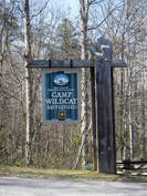
The rest of the day would be road walking with a mix of pavement and gravel. We crossed I-75 and headed toward the Old Wilderness Road to the Wildcat Battlefield monument marking the civil war battle taking place in October 1861. We stopped briefly at the Olive Branch Church to stretch and rest then on to Camp Wildcat.
After exploring the history we headed slightly off trail to Robinson Spring to get water, the last water source for about 5 miles. In my mind I pictured a flowing spring that we could splash around in but, it was just mix of sprinkles coming out of the side of the hill. After about 45 minutes we had about 3 or 4 liters of water and headed off to find a camp.
We set up camp and settled in for the night. It was much warmer today and I went to sleep with my quilt off.
We had about 5 miles between us and a cheeseburger. After a quick breakfast and filtering some water we were off for a cheeseburger! We made it to the 49er truck stop around Noon and ordered some cheeseburgers and a couple Ale 8 Ones to enjoy a meal that wasn't dehydrated. After lunch it was time for some ice cream and fluids for the road. We called "Spark Outfitters" to let Bobby know we'd be ready for extract on Friday at KY-490. A few general details of where the trail comes out and Bobby confirmed that he was familiar with that country - I'm beginning to believe that Bobby has been on nearly every back road and backcountry trail in Kentucky.
The rest of the day would be road walking with a mix of pavement and gravel. We crossed I-75 and headed toward the Old Wilderness Road to the Wildcat Battlefield monument marking the civil war battle taking place in October 1861. We stopped briefly at the Olive Branch Church to stretch and rest then on to Camp Wildcat.
After exploring the history we headed slightly off trail to Robinson Spring to get water, the last water source for about 5 miles. In my mind I pictured a flowing spring that we could splash around in but, it was just mix of sprinkles coming out of the side of the hill. After about 45 minutes we had about 3 or 4 liters of water and headed off to find a camp.
We set up camp and settled in for the night. It was much warmer today and I went to sleep with my quilt off.
Day 6 (Fri):
It was really windy last night. At one point I had a stake give out and my tarp was flopping in the wind. I got really lucky and the stake was laying on my pack under the hammock. Well, maybe I got a little luck. If I was really lucky the stake would have held. You get the point though. I quickly reset the tarp and checked the other stakes and went back to bed.
We got up early (for us) to try to get to our pick up spot by Noon when Bobby planned to be there. We hiked a couple more road miles before finishing out this section on trail. Not long after getting back in the woods we came upon Travis from Canada headed southbound. We chatted with him for a few minutes and then filtered our last bottles of water. We zig-zagged back & forth across streams before climbing up.
We got to KY-490 a little before 11:00 AM which marked the official half way point of the Sheltowee. I strung up the hammock and took a siesta while we waited for Spark.
After a couple disappointing attempts we were back on track and finally had another good section. The weather was excellent and we were treated to numerous water features. Aside from some blow downs I'm surprised how good of shape the trails were in for the amount of recent rain.
There aren't many flat spots on the Sheltowee. It feels like you're always going up or back down and my knees are still feeling it! But, I wish we could just stay on the trail and finish it!
There aren't many flat spots on the Sheltowee. It feels like you're always going up or back down and my knees are still feeling it! But, I wish we could just stay on the trail and finish it!
Honorable Mentions: 1) I did no cook breakfasts this time to save time and not carry as much fuel - I did granola with dark chocolate, powdered milk, carnation instant breakfast and coffee. 2) I traded a cut down poly filled pillow for and inflatable Trekology pillow. It packed smaller and was more comfortable for me.
Honorably Discharged: 1) I tried Altra Lone Peak trail runners and my feet really bothered me. It could be a false correlation since I haven't been backpacking much. It could also be the jump to zero drop shoes, a lack of support. Or, a combination of various things. I really liked how breathable they were since they were not waterproof. But, I may stick to boots for better support. 2) My Sawyer Squeeze also gave me issues again. It seems to be clogged and won't flow. I've tried soaking in vinegar and thought it was good but still gave me fits. Fortunately, Kyle's mini was working fine. I'm undecided if I will replace it with another Sawyer or one of the new Katadyn BeFree filters.
Dishonorably Discharged: Nothing that I can think of.
 RSS Feed
