Back & Forth
Just the Facts
Location: Sheltowee Trace - Daniel Boone National Forest, KY
General Rules and Regulations: Camping is not allowed in the developed areas. Camping is allowed near the developed parking areas when the campsite is at least 200 feet from the edge of the parking area and IS NOT VISIBLE from the parking area. As of May 1, 1991, the following are considered developed areas: Yahoo Falls, Alum Ford, Yamacraw, Blue Heron Overlooks, Blue Heron and access areas along river, East Rim Overlook, Leatherwood Ford, West Entrance, Charit Creek, Twin Arches, Burnt Mill Bridge, Peters Bridge, Bear Creek Overlook, Brewster Bridge, and Honey Creek Overlook.
Camping is strictly prohibited within 25 feet of any cave, cemetery, grave site, historic site/structure, rock shelter, rim of the gorge, trail, roadway, or any other specified location identified by a "No Camping" sign.
Campfires are allowed unless condition dictate otherwise.
Backcountry permits are required within the Big South Fork (not required in the Daniel Boone National Forest in this section).
See the National Park Service website for more details.
Trip Highlights: 3 days; temps ranged from mid 30s to upper 60s; approximately 33 miles. Trees were just starting to change color and streams were high from recent rain.
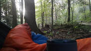
Shelter: Warbonnet Black Bird hammock, Hammock Gear Underquilt, Underground Quilts top quilt, Warbonnet Mamajamba Tarp w/DIY Door Kit
Wildlife: Whitetail deer & birds.
Miscellaneous: http://www.sheltoweetrace.org/
The Sheltowee Trace is Kentucky's long trail. The southern terminus has moved farther south a few times and is currently at the Burnt Mill Bridge in Allardt, TN. The trail runs 323 miles to the northern terminus located off KY 377 at the northern end of the Daniel Boone National Forest (north of Morehead, KY).
Location: Sheltowee Trace - Daniel Boone National Forest, KY
General Rules and Regulations: Camping is not allowed in the developed areas. Camping is allowed near the developed parking areas when the campsite is at least 200 feet from the edge of the parking area and IS NOT VISIBLE from the parking area. As of May 1, 1991, the following are considered developed areas: Yahoo Falls, Alum Ford, Yamacraw, Blue Heron Overlooks, Blue Heron and access areas along river, East Rim Overlook, Leatherwood Ford, West Entrance, Charit Creek, Twin Arches, Burnt Mill Bridge, Peters Bridge, Bear Creek Overlook, Brewster Bridge, and Honey Creek Overlook.
Camping is strictly prohibited within 25 feet of any cave, cemetery, grave site, historic site/structure, rock shelter, rim of the gorge, trail, roadway, or any other specified location identified by a "No Camping" sign.
Campfires are allowed unless condition dictate otherwise.
Backcountry permits are required within the Big South Fork (not required in the Daniel Boone National Forest in this section).
See the National Park Service website for more details.
Trip Highlights: 3 days; temps ranged from mid 30s to upper 60s; approximately 33 miles. Trees were just starting to change color and streams were high from recent rain.
Shelter: Warbonnet Black Bird hammock, Hammock Gear Underquilt, Underground Quilts top quilt, Warbonnet Mamajamba Tarp w/DIY Door Kit
Wildlife: Whitetail deer & birds.
Miscellaneous: http://www.sheltoweetrace.org/
The Sheltowee Trace is Kentucky's long trail. The southern terminus has moved farther south a few times and is currently at the Burnt Mill Bridge in Allardt, TN. The trail runs 323 miles to the northern terminus located off KY 377 at the northern end of the Daniel Boone National Forest (north of Morehead, KY).
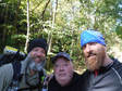
The climate terrorists were saying we'd have good weather with only a slight chance of rain during the time we had planned. Our plan was to pick the trail back up at the official half way marker where left off last time and try to make it to McKee. We put up at Kyle's aunt & uncle's place on Wednesday night and Spark would shuttle us to the half way point at KY-490 on Thursday morning.
Day 1 (Thu):
Spark took us to Milton's for some breakfast before heading for KY-490. After breakfast we made a couple stops for last minute supplies like candy bars, TP, chaffing gel...You know the usual stuff. I'm not sure if the girl checking us out at CVS was confused or scared...Probably both. Along the way we realized the trail guide was still in my truck. Fortunately, we had a map. Rewind to yesterday afternoon - I called Kyle when I got on the road after work to let him know I was eastbound and down. I left a message and Kyle called back shortly at which point we learned that we both had forgot our maps and trail guides. Fortunately, I was only about 20 minutes from home and was able to go back and get mine. Back to the drop off... While making our last minute pack adjustments along side KY-490 Spark imparted his wisdom upon us - you never know when you may need toilet paper! Another life lesson from Spark.
Spark took us to Milton's for some breakfast before heading for KY-490. After breakfast we made a couple stops for last minute supplies like candy bars, TP, chaffing gel...You know the usual stuff. I'm not sure if the girl checking us out at CVS was confused or scared...Probably both. Along the way we realized the trail guide was still in my truck. Fortunately, we had a map. Rewind to yesterday afternoon - I called Kyle when I got on the road after work to let him know I was eastbound and down. I left a message and Kyle called back shortly at which point we learned that we both had forgot our maps and trail guides. Fortunately, I was only about 20 minutes from home and was able to go back and get mine. Back to the drop off... While making our last minute pack adjustments along side KY-490 Spark imparted his wisdom upon us - you never know when you may need toilet paper! Another life lesson from Spark.
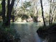
We kicked this section off with about 5 miles of blacktop on KY-490 and KY-89. Shortly after turning off KY-89 onto the gravel of White Oak Branch Rd. we stopped for some lunch along Horse Lick Creek. After lunch and soaking up some sun we continued on toward Horse Lick Rd. We followed Horse Lick Rd. to the point it crossed Horse Lick Creek. From there the trail turned left to bordering the creek. We were relieved to not be crossing the water because it was pretty deep and swift. The relief was short lived. Soon after turning left up the creek we were faced with crossing. We stripped down and took our ice bath in almost waist deep water...It was COLD! After passing Daugherty Ridge Rd. we had a couple more water crossings before we found camp for the night.
The trail in this area is a bit confusing. There's an old, new route and maybe a high water route. Anyhow, after the 3rd water crossing daylight was fading. We quickly spotted a turtle and arrow marker and headed that direction and started looking for a suitable spot to hang. We set up in the dark and got a fire started while we cooked dinner. After dinner and s'mores we headed for our hammocks.
Day 2 (Fri):
We slept in a little before getting up to have some coffee and blueberry breakfast biscuits. Kyle shared some of his biscuits & gravy too! We packed up camp and continued on. We recognized the trail/road on the other side of the creek and tried to pinpoint our location on the map with no luck (the outrageGIS maps are great but not a great deal of detail). We continued walking until we started thinking we hadn't seen a turtle for a while. We came to another point at the creek that looked familiar. But, a lot of things look familiar in the woods. We had passed a fork that went toward the creek and began to second guess ourselves. So, we decided to backtrack to make sure we hadn't missed a turn. Almost immediately after taking the fork on the backtrack I recognized the trail...We had been here yesterday. I even saw my foot prints in the sand! We were baffled...How had we ended up back where we were yesterday? We looked at the map but, there wasn't enough detail for us to figure out where we went wrong. We continued to backtrack until we realized where we got back onto yesterday's trail. We continued backtracking to the next trail marker - Where did we miss the turn. We re-traced that section several times without seeing a missed turn.
We slept in a little before getting up to have some coffee and blueberry breakfast biscuits. Kyle shared some of his biscuits & gravy too! We packed up camp and continued on. We recognized the trail/road on the other side of the creek and tried to pinpoint our location on the map with no luck (the outrageGIS maps are great but not a great deal of detail). We continued walking until we started thinking we hadn't seen a turtle for a while. We came to another point at the creek that looked familiar. But, a lot of things look familiar in the woods. We had passed a fork that went toward the creek and began to second guess ourselves. So, we decided to backtrack to make sure we hadn't missed a turn. Almost immediately after taking the fork on the backtrack I recognized the trail...We had been here yesterday. I even saw my foot prints in the sand! We were baffled...How had we ended up back where we were yesterday? We looked at the map but, there wasn't enough detail for us to figure out where we went wrong. We continued to backtrack until we realized where we got back onto yesterday's trail. We continued backtracking to the next trail marker - Where did we miss the turn. We re-traced that section several times without seeing a missed turn.
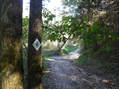
We kept backtracking, past last night's camp and back to the last water crossing where the trail marker and arrow was. The arrow was definitely pointing to where we had just been. Studying the marker it seemed to be hung for those coming down the hill from on what I think is Raccoon Creek Rd. We filtered some water and headed that way keeping our eyes peeled for that elusive turtle. Finally another turtle signalling us in the right direction.
It turns out that we got misdirected by the markings for the old or high water route. We basically did a loop back to where we crossed the creek not far past Daugherty Ridge Rd. I also found out from the STA director that this is common area of confusion that is being worked on.
It turns out that we got misdirected by the markings for the old or high water route. We basically did a loop back to where we crossed the creek not far past Daugherty Ridge Rd. I also found out from the STA director that this is common area of confusion that is being worked on.
We walked a bit on gravel crossing a few streams and meeting a local couple on a side by side before we got to S-Tree Tower Rd. It turns out the gentleman on the side by side has also been section hiking the Sheltowee and was showing his wife some of the trail. We stopped for lunch at S-Tree Tower Rd. I was now pretty familiar with where we were. I've rode bikes many times around S-Tree and Turkey Foot. This is area sees a lot use and the effects are obvious. Not long after lunch we picked up the shared use part of the trail. I gotta say, aside from the pavement walking, this has been my least favorite section.
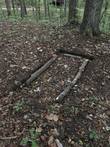
We stopped for camp at Forest Road 3062. I'm pretty sure we camped next to grave or some crime scene. But, we didn't want to set up in the dark again and we were tired enough that it didn't matter. We hung our hammocks and tarps and then had dinner. Not long after we finished eating it started to rain. So, we headed for cover and chilled in our hammocks while we radioed Spark to give an update on our location and expected extraction point. Now that we had a pick up point, we needed a time...This was decided by the UK game and Spark's estimated drive time (and perhaps a healthy margin of error). The rain came and went a few times before bedtime. The rain settled in over night with waves of showers.
We stopped for camp at Forest Road 3062. I'm pretty sure we camped next to grave or some crime scene. But, we didn't want to set up in the dark again and we were tired enough that it didn't matter. We hung our hammocks and tarps and then had dinner. Not long after we finished eating it started to rain. So, we headed for cover and chilled in our hammocks while we radioed Spark to give an update on our location and expected extraction point. Now that we had a pick up point, we needed a time...This was decided by the UK game and Spark's estimated drive time (and perhaps a healthy margin of error). The rain came and went a few times before bedtime. The rain settled in over night with waves of showers.
Day 3 (Sat):
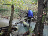
We had about 14 miles to get to Turkey Foot Campground and had to meet Spark there by 3:30. So, we were up and hiking as daylight broke. It was still cool and misty when we started out. We stopped just south of US-421 to filter water. In an effort to not have to take our shoes off & on and to stay dry we crossed Birch Lick Creek at US-421 via a downed tree. After walking the tight rope over the creek we walked US-421 toward McKee until the turn off to Turkey Foot. Back on trail we crossed Elisha Branch creek and headed up the long rocky climb. I remember this hill being long on a bike and it certainly didn't feel any shorter on foot.
We had about 14 miles to get to Turkey Foot Campground and had to meet Spark there by 3:30. So, we were up and hiking as daylight broke. It was still cool and misty when we started out. We stopped just south of US-421 to filter water. In an effort to not have to take our shoes off & on and to stay dry we crossed Birch Lick Creek at US-421 via a downed tree. After walking the tight rope over the creek we walked US-421 toward McKee until the turn off to Turkey Foot. Back on trail we crossed Elisha Branch creek and headed up the long rocky climb. I remember this hill being long on a bike and it certainly didn't feel any shorter on foot.
We stopped along Forest Road 3115 for an early lunch before the rain moved back in. After a quick lunch we headed on for KY-89. From KY-89 it was about 4 miles to Turkey Foot Campground and there had been a light rain since just shortly after lunch.
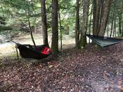
There were a few more water crossings between KY-89 and the campground. But, nothing that couldn't be rock hopped. We beat Spark to the extraction point about 30 minutes ahead of target. If we hadn't had the back & forth south of S-Tree we would have had a leisurely stroll into Turkey Foot. While we waited for pick up we hung our tarps to dry and strung up hammocks to relax in until our chariot arrived. About an hour later we were headed back to watch the UK game and some home cookin!
There were a few more water crossings between KY-89 and the campground. But, nothing that couldn't be rock hopped. We beat Spark to the extraction point about 30 minutes ahead of target. If we hadn't had the back & forth south of S-Tree we would have had a leisurely stroll into Turkey Foot. While we waited for pick up we hung our tarps to dry and strung up hammocks to relax in until our chariot arrived. About an hour later we were headed back to watch the UK game and some home cookin!
While this wasn't the most scenic or fun section we've done, it was still good. We had good weather and no major issues. We managed to get 2 sections in this season in hopes of doing the same next year and finishing our turtle hunt.
Honorable Mentions: 1) I picked up one of the $15 ultra light BRS stoves in favor of my fancy feast alcohol stove. This little thing worked like a champ and I really enjoyed the ease of use over an alcohol stove. 2) I left the Altra Lone Peaks at home and wore my Pearl Isumi trail runners and loved them. I really like how much more breathable non "waterproof" shoes are and how much quicker they dry. That said, much colder and I would probably go back to my Salomon Quest 4D boots.
Honorably Discharged: For another similar trip I'd keep this same kit.
Dishonorably Discharged: Everything is a keeper at this point.
 RSS Feed
