Rough Country Boys
Just the Facts
Location: Sheltowee Trace - Big South Fork National Recreation Area, TN/KY and Daniel Boone National Forest, KY
General Rules and Regulations: Camping is not permitted within 100 feet of the center line of Bandy Creek Access Road, Tennessee State Highway 297 (Leatherwood Ford Road), Blue Heron Access Road (Mine 18 Road), and the Blue Heron Overlook Road.
Camping is not allowed in the developed areas. Camping is allowed near the developed parking areas when the campsite is at least 200 feet from the edge of the parking area and IS NOT VISIBLE from the parking area. As of May 1, 1991, the following are considered developed areas: Yahoo Falls, Alum Ford, Yamacraw, Blue Heron Overlooks, Blue Heron and access areas along river, East Rim Overlook, Leatherwood Ford, West Entrance, Charit Creek, Twin Arches, Burnt Mill Bridge, Peters Bridge, Bear Creek Overlook, Brewster Bridge, and Honey Creek Overlook.
Camping is strictly prohibited within 25 feet of any cave, cemetery, grave site, historic site/structure, rock shelter, rim of the gorge, trail, roadway, or any other specified location identified by a "No Camping" sign.
Campfires are allowed unless condition dictate otherwise.
Backcountry permits are required within the Big South Fork (not required in the Daniel Boone National Forest in this section).
See the National Park Service website for more details.
Trip Highlights: 6 days/5 nights; temps ranged from low 40s to low 90s; approximately 95 miles (per GPS); elevation was approximately 713' - 1,825'. The trees were past budding/blooming but, the wildflowers were in bloom and we watched the mountain laurel bloom while we were on the trail.
Shelter: Warbonnet Black Bird hammock, DIY top quilt and under quilt, Warbonnet Mamajamba Tarp w/DIY Door Kit
Wildlife: Snakes (black snake & baby Copperhead), whitetail deer, squirrels, chipmunks, toads, ducks and bobcat
Miscellaneous: http://www.sheltoweetrace.org/ http://www.ccl-bsf.com/
The Sheltowee Trace is Kentucky's long trail. The southern terminus has moved farther south a few times and is currently at the Burnt Mill Bridge in Allardt, TN. The trail runs 319 miles to the northern terminus located off KY 377 at the northern end of the Daniel Boone National Forest (north of Morehead, KY).
This was our first section of tracking the turtle on the Sheltowee Trace. We planned for a 7 day/6 night trip covering approximately 84 miles from the southern terminus at the Burnt Mill Bridge north to Whitley City, KY. The best laid plans change though.
Detailed information on the Sheltowee is hard to come by and, it seems some of the details are, well, not that detailed. For example, from what we were able to find the distance from the previous southern terminus at Leatherwood to the new southern terminus is to be 14 miles. But, from what we could determine it is actually about 18.5 miles. We also had 3 navigation setbacks, one of which was significant. The trail markers are pretty good with the exception of not having some in key places that would help (like at a couple of trail intersections/crossings). I suspect that some markers may have been torn down by vandals. Also, the Nat Geo map and trail guide we used had at least one inaccuracy (the trail must have been rerouted in the Bandy Creek campground and, the rangers had little to no knowledge of the trail).
We both have roots in this area making this section a bit more special. It also gave us the luxury of being dropped off and picked up by my friend's uncle. And, to boot it meant we got to eat like kings before we hit the trail and when we came out! So, we arrived the night before to dine on country ribs, fried squash, green beans & potatoes, cornbread and finished it off with a Butterfinger ice cream dessert!
Day 1 (Wed): Our goal for the first day was to make it to the Leatherford trailhead, which was supposed to be 14 miles.
We woke up early to fill up on eggs, sausage, bacon, goetta, biscuits and gravy. After enjoying a good ole country breakfast we loaded up and headed south to the Burnt Mill Bridge. After arriving at the trailhead we made a few last minute adjustments and sprayed down with bug spray.
We woke up early to fill up on eggs, sausage, bacon, goetta, biscuits and gravy. After enjoying a good ole country breakfast we loaded up and headed south to the Burnt Mill Bridge. After arriving at the trailhead we made a few last minute adjustments and sprayed down with bug spray.
After a pep talk from Bobby that went something like this - "That's some rough country boys!" we were ready, we hoped, to head off. With the words of Bobby fresh in our minds we began tracking the elusive turtle.
From the Burnt Mill Bridge the trail follows the Clear Fork River before leaving to join the John Muir trail north toward the Honey Creek trailhead. North of the Honey Creek trailhead there were several downed trees and the new section of the John Muir/Sheltowee Trace was littered with downed and broken trees. After weaving our way through the blow-downs we rejoined the older established trail. We were nearing 14 miles but were still a good piece from Leatherford. With daylight fading we started looking for a place to hang. When we found a suitable spot to set up camp we had covered 14.5 miles our first day. We strung up our hammocks, hung our bear bags and started a campfire (more for morale than anything). With no sign of rain and a clear night we decided to go topless and not hang tarps. This was a first for me and it was really nice to star gaze as we fell asleep.
From the Burnt Mill Bridge the trail follows the Clear Fork River before leaving to join the John Muir trail north toward the Honey Creek trailhead. North of the Honey Creek trailhead there were several downed trees and the new section of the John Muir/Sheltowee Trace was littered with downed and broken trees. After weaving our way through the blow-downs we rejoined the older established trail. We were nearing 14 miles but were still a good piece from Leatherford. With daylight fading we started looking for a place to hang. When we found a suitable spot to set up camp we had covered 14.5 miles our first day. We strung up our hammocks, hung our bear bags and started a campfire (more for morale than anything). With no sign of rain and a clear night we decided to go topless and not hang tarps. This was a first for me and it was really nice to star gaze as we fell asleep.
Day 2 (Thu): We awoke to birds singing and the view of a clear sky from the hammocks. We had a dry camp so the we ate some snacks and planned to cook breakfast on the trail since we weren't far from the Oneida and Western Bridge over the Big South Fork Cumberland River. Back on the trail we headed down to the Oneida and Western Bridge where we met a guy getting ready to put in for a canoe ride to Leatherwood. After crossing the river we found a spot to rest and have breakfast.
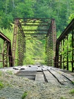
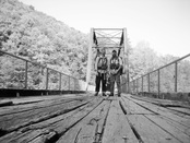
We followed the river to the Leatherwood trailhead, which ended up being at the 18.4 mile mark for us. We stopped there, used the facilities, had lunch and unloaded our trash. After lunch we took the road bridge to the trail on the other side of the river. While crossing the river we saw the same paddler from the Oneida and Western Bridge at the dock.
We followed the river to the Leatherwood trailhead, which ended up being at the 18.4 mile mark for us. We stopped there, used the facilities, had lunch and unloaded our trash. After lunch we took the road bridge to the trail on the other side of the river. While crossing the river we saw the same paddler from the Oneida and Western Bridge at the dock.
We met a pair of Forestry workers coming south clearing blowdowns from a winter ice storm. We were thankful they had cleared blowdowns ahead of us and we didn't have to climb through them!
We had our first of 3 navigation issues on day 2 when we missed a switchback after the trail leaves the river. The trail got really rough and was back on the river. So, we knew something wasn't right. We backtracked to the last trail marker and saw the switchback we missed. Thankfully, we realized something was off before we went too far out of the way.
Our goal was to make it to the Bandy Creek Campground today. We made it to the campground around 8:00 and had another 14.5 mile day. After dinner we took advantage of the shower house before retiring to our hammocks. Day 2 was a hard day because my feet were bothering me. I've never had a problem with blisters or sore feet. But, by the time we made it to Bandy Creek my left toe had a sore spot that would require attention in the morning.
Day 3 (Fri): We packed up and had breakfast at the campground. Before hitting the trail I doctored my feet to ready myself for another day. We thought we could make it past the Charit Creek Lodge today. But, we had a hard time getting back on the trail. The map and hiker's guide showed the trail going through the campground but, we couldn't pick up the trail markers (the trail actually goes around the edge of the campground). Two of the three park rangers didn't even know of the Sheltowee (or even where we were on the map!). A third kind of knew but, was not very confidence inspiring to say the least. After wandering around for much of the morning we finally found a turtle...Unfortunately, we saw some markers but not others going another direction. We followed the markers and were seeing landmarks in the guide book (so we thought), like "State Forest Boundary" signs and orange blazes. Our instincts were telling us we were not headed in the right direction but, since we were seeing what we thought were confirmations we plundered onward (this proved to be a costly mistake for us). When we came upon the Litton Homestead we knew without a doubt that we were off course. We eventually backtracked to the campground where we studied the map and realized where we went off course. Back on the trail it was now around 1:00. We had hiked 11 miles and made no forward progress! This was a BIG mental blow.
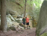
The trail leading out of Bandy Creek is shared with horses and was mostly either sand or large loose stone <read it sucked>. Walking miles of sand and stone was brutal, made worse by a silly navigation mistake. We passed a nice rock overhang and took a long lunch break. After resting we headed down hill to Laurel Creek. We were still determined to make Charit Creek Lodge and pushed to get there. After several creek crossings it was time to go back up.
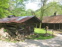
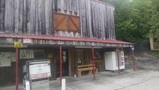
We finally made it to the lodge after 14.2 miles. On the way to the lodge we spotted a spectacular campsite on the creek just south of the lodge. After checking out the lodge and indulging in a Coke and a Dr Pepper we went back to "The Island" we spotted on the way in to set up camp.
Note: The Charit Creek Lodge is a lodge/hostel. They have group rooms and private cabins and offer limited service to full service (bed, meals, showers, etc.) and Gregg and his crew are great people.
The trail leading out of Bandy Creek is shared with horses and was mostly either sand or large loose stone <read it sucked>. Walking miles of sand and stone was brutal, made worse by a silly navigation mistake. We passed a nice rock overhang and took a long lunch break. After resting we headed down hill to Laurel Creek. We were still determined to make Charit Creek Lodge and pushed to get there. After several creek crossings it was time to go back up.
We finally made it to the lodge after 14.2 miles. On the way to the lodge we spotted a spectacular campsite on the creek just south of the lodge. After checking out the lodge and indulging in a Coke and a Dr Pepper we went back to "The Island" we spotted on the way in to set up camp.
Note: The Charit Creek Lodge is a lodge/hostel. They have group rooms and private cabins and offer limited service to full service (bed, meals, showers, etc.) and Gregg and his crew are great people.
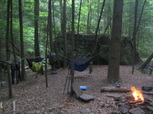
We went through our evening ritual of setting up our hammocks, stringing up a bear bag and resting our feet. We enjoyed another Coke from the lodge while we were hypnotized by the fire and the babbling creeks. This really was a nearly ideal spot to hang. Today was a really tough day both physically and mentally. Finding such a good camp and the convenience of the lodge really helped with the day we had. If not for our navigation issue we would have been well past the Charit Creek Lodge when time to set up camp.
Day 4 (Sat): After the day we had yesterday we weren't all that motivated to get an early start so, we slept in. When packed up we went to the lodge to fix our breakfast and use the facilities. We thanked Gregg and said our farewells to everyone before continuing north.
We estimated that we were about 30 miles from Yamacraw and for now our updated plan was to come out at the Yamacraw Bridge on Day 6.
The trail past the lodge runs along Station Camp Creek and was pretty but, it was still horse trail which made it rough walking. Once the trail reached the Big South Fork Cumberland River it was not nearly as scenic. The trail bounced on and off the horse trail until we headed up over the ridge near Burke Knob. This was one of our favorite sections, despite being a challenging climb. The trail worked its way down off the ridge toward No Business Creek. Off the ridge we followed the creek with a horse trail/forest road until we headed back up toward the John Muir Overlook.
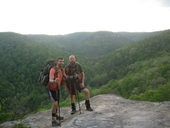
Before leaving the water source we took a break to wash off, rest our feet and eat. After eating we loaded up on water knowing that we would likely be spending the night atop Chestnut Ridge. Loaded with water we started the climb up toward the overlook. We reached the overlook 58.2 miles after we started 3 days prior. After taking in the views from the overlook we pushed on to get to lower elevation for more opportunities to hang.
A couple miles past the overlook we found a suitable campsite. We thought being away from water would give some relief from the bugs...We were wrong. The bugs were getting to be maddening! We quickly set up camp and retreated to the safety of our bug nets.
A couple miles past the overlook we found a suitable campsite. We thought being away from water would give some relief from the bugs...We were wrong. The bugs were getting to be maddening! We quickly set up camp and retreated to the safety of our bug nets.
Day 5 (Sun): On day 5 we would join the "old" Sheltowee approximately 9 miles north of Pickett State Park. We would also be leaving Tennessee and crossing into Kentucky. This is also about the time the battery on my camera died - I took a few more pictures with my phone without draining all the battery for calls when we came off the trail.
This day was a very pretty day. The scenery was awesome but, rough - there were a lot of blowdowns and the trail didn't seem well traveled and a fair amount of elevation change, much like the rest of the trail!
Breakfast was quick no cook food and then back on the trail. We would be crossing Divide Rd prior to descending to Massey Branch and Rock Creek where we would pick up the original trail as we hit 67.3 miles. The trail leading down to Rock Creek followed an old rail bed showing a glimpse of coal mining life from years past. This was another of our favorite areas.
The trail follows Rock Creek past the Great Meadows Campground. It was around the campground on the trail that we saw our first sign of bear - bear scat. As we approached the campground we picked up the undeniable scent of charcoal and grilling! In the back of both of our minds we were hoping for an offering of a burger or hot dog.
The creek was busy with children playing. They didn't quite know what to think of two guys popping out of the woods into the creek. We crossed the creek and found some shade and took a long break. Unfortunately, no scraps came our way and we only dined on our trail food.
The major disappointment with the Great Meadows Campground, besides not being offered a burger, was that they did not have trash bins and the pit toilets did not have paper, and didn't appear to have been cleaned any time in recent history. We chatted with a gentlemen at the water spigot about our adventure and his attempt to pull some trout from Rock Creek. He and his wife were kind enough to take our trash and save us a few ounces as we continued.
We crossed Rock Creek again and continued chasing turtles. The trail passed near the Hemlock Grove Shelter. We continued until the next water source where we had dinner. The trail past here was very cool as it wound its way up a creek littered with house size boulders and past a waterfall. We hiked until nearly dark, 8:45, before we stopped and set up camp. After a 18.2 mile/12 hour day we were spent. We did light a campfire and enjoyed its glow as we readied for bed.
Day 6 (Mon): We were just shy of the Peters Mountain trailhead which is 14 miles from Yamacraw. Another dry campsite meant snacks on the trail again. We estimated our next water source to be about 4 miles out.
Today would be a decent amount of forest roads and old logging and mining roads. Once at the Peters Mountain trailhead we had about a 5 mile walk on gravel forest roads...Well, it should have been 5 miles. This was our third navigation blunder. We missed a turn and took a wrong forest road a couple miles out of the way. Once back on track we hiked the road until our turn off where we took a lunch break.
After lunch we could hear thunderstorms moving in and the sky was darkening. It wasn't long before the rain started. We stopped for a break under a rock overhang and had some snacks while we waited for the rain to let up. Once the rain lightened we continued on a ridge walk before coming back down to forest roads and paved roads. The last stretch would be almost all forest roads and mining roads. The trail took us past 2 old mine entrances and along the creek before coming into Yamacraw. Our last water ford would be Rock Creek which was pretty wide. I imagine this could get deep and swift. Back on dry land we made a bee line for the bridge. We made it to the Little South Fork Grocery around 5:15 and bought some drinks and snacks while we patiently waited for our ride...Then it was off to the Dairy Bar and then a fish fry!
Summary: I really enjoyed the trip. The area is special to us and the scenery is great. We learned to trust our instincts - When something seems off stop and take the time to figure it out (it took us 3 lessons to learn this!). Also, don't trust any single source of info. Things change so often that info can easily be out of date or just inaccurate.
We are looking forward to our next section. Next time we will plan on covering less ground to allow us time to travel off trail to see nearby sites. This will also be less physically demanding.
We are looking forward to our next section. Next time we will plan on covering less ground to allow us time to travel off trail to see nearby sites. This will also be less physically demanding.
Honorable Mentions: 1) Snake Skins - I made a set of snake skins out of NoSeeUm for my tarp. The snake skins really simplified the setup and takedown of the tarp. 2) Dr. Bronner's Soap - We packed about 2 - 3 fl oz of soap each and this allowed us to clean up and wash some clothes. 3) Gold Bond - My hiking partner brought a travel size container of Gold Bond powder which was great to powder your feet and anything else! 4) Mountain Laurel Gaiters - First time using gaiters and got some for this trip because I was tired of empty trail trash out of my boots.
Honorably Discharged: 1) Ribz Pack - I loved the convenience of having a front pack. It allowed me to have all my snacks, maps, etc. at my finger tips as well as help balance the load. But, it trapped so much heat in that it was uncomfortable. I eventually ended up carrying it in my backpack. It is also a bit heavy at around 11 oz (empty). I will probably deploy the the Ribz Pack again in cold weather but, for now it will be pulling fishing duty.
Dishonorably Discharged: I can't think of anything on the trip that was an out right fail. There are a few things that I either did not use, or didn't use enough, and others items that I could use in place of multiple items (baseball hat and shemagh will be replaced by a boonie hat).
Food: Here was the meal plan for this trip. My goal was to hit 3,000 calories per day at about 1.5 lb/day.
 RSS Feed
