A solo trip in and around DBNF
With a few days of vacation to use and a favorable weather forecast I decided to use one of those days to prep the bike and gear and the others to extend the weekend for a trip through the Daniel Boone National Forest (DBNF). The DBNF spans 21 counties and encompasses 2.1 million acres, 708,000 acres of which are federally owned. I had been playing around with GPS tracks and maps trying to tie routes together to make a loop in the DBNF. While the DBNF extends north and south across much of the state of Kentucky, it is not very wide. And, with the significant amount of private land within DBNF this all makes it challenging to map a mostly off road loop without doubling back. But, riding the same road/trail the opposite direction still gives a different perspective.
Day 1
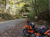
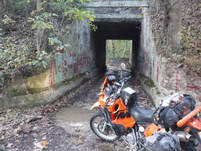
I left late morning on a Thursday, later than I had hoped for. I didn't get to Slade until around 2:00. My goal was to get to the Turkey Foot Campground to camp. With a full day this would have been easy. I gassed up and headed for the Nada Tunnel. I've been through the tunnel multiple times but, still had to stop for a photo. The route I had planned was using bits of the Kentucky Adventure Tour, the Daniel Boone Backcountry Byway and some map routing online. So, I was counting on some route finding on the fly. I just didn't expect it right off the rip. I crossed the Red River and turned onto N Fork Rd. A few miles down, around Indian Creek, the road was closed and they had an excavator working on a wash out. This meant I'd miss Spaas Creek because there was no quick easy route around. So I backtracked to pick up my track heading south around Chop Chestnut Ridge.
Day 1
I left late morning on a Thursday, later than I had hoped for. I didn't get to Slade until around 2:00. My goal was to get to the Turkey Foot Campground to camp. With a full day this would have been easy. I gassed up and headed for the Nada Tunnel. I've been through the tunnel multiple times but, still had to stop for a photo. The route I had planned was using bits of the Kentucky Adventure Tour, the Daniel Boone Backcountry Byway and some map routing online. So, I was counting on some route finding on the fly. I just didn't expect it right off the rip. I crossed the Red River and turned onto N Fork Rd. A few miles down, around Indian Creek, the road was closed and they had an excavator working on a wash out. This meant I'd miss Spaas Creek because there was no quick easy route around. So I backtracked to pick up my track heading south around Chop Chestnut Ridge.
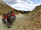
From the Slade area I worked south to Beatyville. It rained a little at home Thursday night but, not much. And, it had been really dry. But, Kentucky got a quite a bit more ran than southwest Ohio. The back roads were wet with plenty of standing water which was mostly chocolaty brown making it impossible to see what was below the water's surface. I tip toed around and through several water holes along Big Sinking Creek, north of Peaceful Valley near the dam at Zachariah Fork. I talked to a couple that lives here and they said they had about 5 inches of rain within a week. That explained all the water holes.
A portion of Bald Rock Fork Rd follows the Bald Rock Fork. Most of the time this is probably a dry creek bed. Not the case on this day. Rather than taking a chance I parked the bike and walked the creek. It was deep in spots with some tricky rocks. I used rocks and branches as markers to know when to cross back & forth and where to to go.
Bald Rock is a popular rock climbing spot attracting people from all over. I stopped and chatted with a group of four (counting their dog) from Australia there climbing. Beatyville is just south of Bald Rock. For some reason I got turned around in Beatyville and had to make a few laps around town to get my bearings and get out. I eventually made it out following the Kentucky River west to Heidelberg. I didn't recognize KY 399 until I got into Heidelberg and saw the bridge over the Kentucky River. Then I remembered hiking north through Heidelberg on the Sheltowee Trace early in the year. I would cross over and ride on several sections of the Sheltowee this trip.
I made it to Turkey Foot with just enough time to set up my tent without a headlamp. With the tent up I starting fixing dinner and calling home to check in. The good news is that the fire ban had just been lifted thanks to the recent rain. The bad news is everything was so wet it wasn't even worth the effort to have a campfire. So, I ate and went to bed.
Day 2
After some oatmeal and coffee for breakfast I left Turkey Foot Campground headed for McKee for gas and water. After filling up I headed across US 421 to head in the general direction of S-Tree. The morning would involve a little route finding. But, it was easy to find a route in the general direction I was going, which was toward the Camp Wildcat Battlefield near Livingston. I hiked a lot of these roads too because the Sheltowee follows these roads in the area.
After Camp Wildcat I worked my way to Laurel Lake. I've been here a few times, both on foot and on a bike. The lake is a reservoir built in 1977 by the U.S. Army Corps of Engineers. The dam was finished in 1974 and hydro power followed in 1977.
Not far past Laurel Lake I crossed the Cumberland River at Cumberland Falls. I didn't stop as I planned to stop on my way back through the next day. So, I pressed on to Whitley City. My plan was to stop and see friends in Stearns/Revelo before going to the Blue Heron Campground. They weren't expecting me so, I wasn't even sure if they would be home (although I figured they would be). I rolled down their driveway around 5:00 and knocked on the door to present to them what drifted in. I explained that I happened to be in the area and figured I'd best stop in to say hello and was invited to stay with them. It didn't take much convincing to sleep in a warm bed rather than on the ground in a tent.
Spark took me to the Dairy Bar and I had dinner and got a peanut butter fudge milkshake. After dinner we talked for a bit and after a hot shower I was ready for bed.
Day 3
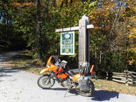
In the morning Spark wanted to go to Arby's, AKA liar's corner. From Arby's it was back to the house and time to head out. Before leaving the area I rode down to the Barthell Mine and Blue Heron. From there I hiked to an overlook of the Cumberland River and then refreshed my memory of the Blue Heron Campground. I wanted to recall whether there were any sites that a hammock could be used on - There were a few options but not a lot.
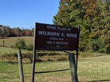
After the campground I made the short ride to my mom's old home place which isn't farm from home place of Wilburn K. Ross, WWII Medal of Honor Recipient. There's not much here to even know a home once stood here unless you find the well or corner stones...It's just memories now. But, it still feels special. From here I began north again. I stopped in Whitley for gas. I noticed an offroad shop so I stopped in to buy a 21" tube. I had realized I forgot to bring any tubes and only had patches. So, rather than continue to press my luck I picked up a front tube.
I stopped at the Cumberland Falls on the way back through. It's hard not to stop here even though I've done so many times. After leaving the falls I stopped at the Laurel Lake Resort for lunch then it was time to push on to S-Tree where I planned to camp.
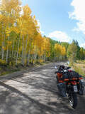
I back tracked some of what I road but had tried to route a track that ran parallel without riding all of the same exact route backwards. I was able to accomplish this for a good bit on the way back north. But, it was at the cost of riding a fair amount of slab. Which was okay since it allowed me to make a little better time. Even though I was riding some asphalt it was still fun roads and scenic.
I made it to the S-Tree campground and had my pick of campsites. I cruised around scanning for any firewood to scavenge and a site that looked good. With my site picked out I set up camp and then went about gathering firewood. With my firewood amassed I started a fire and began cooking dinner. With the luxury of a campfire it was easier to stay up after dark. I relaxed by the fire before heading for bed.
In the morning Spark wanted to go to Arby's, AKA liar's corner. From Arby's it was back to the house and time to head out. Before leaving the area I rode down to the Barthell Mine and Blue Heron. From there I hiked to an overlook of the Cumberland River and then refreshed my memory of the Blue Heron Campground. I wanted to recall whether there were any sites that a hammock could be used on - There were a few options but not a lot.
After the campground I made the short ride to my mom's old home place which isn't farm from home place of Wilburn K. Ross, WWII Medal of Honor Recipient. There's not much here to even know a home once stood here unless you find the well or corner stones...It's just memories now. But, it still feels special. From here I began north again. I stopped in Whitley for gas. I noticed an offroad shop so I stopped in to buy a 21" tube. I had realized I forgot to bring any tubes and only had patches. So, rather than continue to press my luck I picked up a front tube.
I stopped at the Cumberland Falls on the way back through. It's hard not to stop here even though I've done so many times. After leaving the falls I stopped at the Laurel Lake Resort for lunch then it was time to push on to S-Tree where I planned to camp.
I back tracked some of what I road but had tried to route a track that ran parallel without riding all of the same exact route backwards. I was able to accomplish this for a good bit on the way back north. But, it was at the cost of riding a fair amount of slab. Which was okay since it allowed me to make a little better time. Even though I was riding some asphalt it was still fun roads and scenic.
I made it to the S-Tree campground and had my pick of campsites. I cruised around scanning for any firewood to scavenge and a site that looked good. With my site picked out I set up camp and then went about gathering firewood. With my firewood amassed I started a fire and began cooking dinner. With the luxury of a campfire it was easier to stay up after dark. I relaxed by the fire before heading for bed.
Day 4
I broke camp, loaded the bike and headed out planning to get a light breakfast and coffee along the way. On the way out I found that two jeeps were camped in the sites across the road...I guess I didn't have the place to myself.
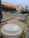
To go back to Slade would basically be retracing my steps or taking slab. So, I decided to poke around S-Tree and work my way to US 421 and take that home via Paris. I stopped in Paris for a sandwich and coffee and then continued home.
I broke camp, loaded the bike and headed out planning to get a light breakfast and coffee along the way. On the way out I found that two jeeps were camped in the sites across the road...I guess I didn't have the place to myself.
To go back to Slade would basically be retracing my steps or taking slab. So, I decided to poke around S-Tree and work my way to US 421 and take that home via Paris. I stopped in Paris for a sandwich and coffee and then continued home.
 RSS Feed
