Arches & Water Fords
Just the Facts
Location: Big South Fork National River and Recreation Area - TN West Area
General Rules and Regulations: Per the NPS - Camping is not allowed in the developed areas. Camping is allowed near the developed parking areas when the campsite is at least 200 feet from the edge of the parking area and IS NOT VISIBLE from the parking area. As of May 1, 1991, the following are considered developed areas: Yahoo Falls, Alum Ford, Yamacraw, Blue Heron Overlooks, Blue Heron and access areas along river, East Rim Overlook, Leatherwood Ford, West Entrance, Charit Creek, Twin Arches, Burnt Mill Bridge, Peters Bridge, Bear Creek Overlook, Brewster Bridge, and Honey Creek Overlook.
Camping is strictly prohibited within 25 feet of any cave, cemetery, grave site, historic site/structure, rock shelter, rim of the gorge, trail, roadway, or any other specified location identified by a "No Camping" sign.
Campfires are permitted unless restricted by current conditions. Campfires are not allowed under arches, rock shelters, or near historical structures. Only dead and down trees may be used for firewood.
Backcountry permits are required and can be purchased online for $5.
Trip Highlights: 2days/1 night; temps ranged from low 40s to low 80s; arches & water crossings
Stats: 20.9 miles, Moving Avg - 2.7 MPH, Min Elevation: 896', Max Elevation: 2,030'
Menu: Oatmeal, Pork Al Pastor, Hickory Smoked Tuna and snacks
Shelter: Warbonnet Outdoors Blackbird Hammock, Warbonnet Outdoors Mamajamba tarp, Underground Quilts Top Quilt and Hammock Gear Underquilt.
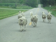
Wildlife: Deer, birds and sheep
Miscellaneous: www.nps.gov/biso/planyourvisit/backcountry-hiking-and-camping.htm
Location: Big South Fork National River and Recreation Area - TN West Area
General Rules and Regulations: Per the NPS - Camping is not allowed in the developed areas. Camping is allowed near the developed parking areas when the campsite is at least 200 feet from the edge of the parking area and IS NOT VISIBLE from the parking area. As of May 1, 1991, the following are considered developed areas: Yahoo Falls, Alum Ford, Yamacraw, Blue Heron Overlooks, Blue Heron and access areas along river, East Rim Overlook, Leatherwood Ford, West Entrance, Charit Creek, Twin Arches, Burnt Mill Bridge, Peters Bridge, Bear Creek Overlook, Brewster Bridge, and Honey Creek Overlook.
Camping is strictly prohibited within 25 feet of any cave, cemetery, grave site, historic site/structure, rock shelter, rim of the gorge, trail, roadway, or any other specified location identified by a "No Camping" sign.
Campfires are permitted unless restricted by current conditions. Campfires are not allowed under arches, rock shelters, or near historical structures. Only dead and down trees may be used for firewood.
Backcountry permits are required and can be purchased online for $5.
Trip Highlights: 2days/1 night; temps ranged from low 40s to low 80s; arches & water crossings
Stats: 20.9 miles, Moving Avg - 2.7 MPH, Min Elevation: 896', Max Elevation: 2,030'
Menu: Oatmeal, Pork Al Pastor, Hickory Smoked Tuna and snacks
Shelter: Warbonnet Outdoors Blackbird Hammock, Warbonnet Outdoors Mamajamba tarp, Underground Quilts Top Quilt and Hammock Gear Underquilt.
Wildlife: Deer, birds and sheep
Miscellaneous: www.nps.gov/biso/planyourvisit/backcountry-hiking-and-camping.htm
I had planned on hiking another section of the Sheltowee Trace with a friend during this time. Unfortunately, some things came up preventing us from completing our 2nd section. The weather would have been perfect so, I wanted to at least get out somewhere. I really enjoyed the southern section of the Sheltowee and wanted to get back to that area. From Sawmill trailhead I hiked the Slave Falls to Charit Creek Trail where I took the Twin Arches Loop Trail past the arches. From the Charit Creek Lodge I took the Sheltowee south (I actually took the horse trail/road since I had already hiked the this part of the Sheltowee) to the Laurel Fork Creek Trail which would take me all the way back to the trailhead. Even though I only planned a 15-20 mile route I allowed for a 2 night trip since I am still not in trail shape and read about the trail being difficult to navigate.
 Traffic jam
 Day 1: I headed south early Saturday morning and arrived at the Sawmill trailhead around 12:30 PM. I could have made it a little sooner but, got caught up in some traffic on KY-167 outside of Monticello.
I thought I had about a 6 to 7 mile hike to make it to the Charit Creek Lodge where I planned to stop for the night. By the time I hiked around to see the sights and look for a decent campsite I had logged about 9 miles.
I thought I had about a 6 to 7 mile hike to make it to the Charit Creek Lodge where I planned to stop for the night. By the time I hiked around to see the sights and look for a decent campsite I had logged about 9 miles.
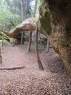 Needle Arch
 The first spur trail to Slave Falls is an easy hike, just over a mile from the trailhead. Slave Falls is about a 60' tall waterfall but it does not have a lot of flow. Still worth the .2 mile walk to see it. And the trail out is probably what makes it most worth it.
The name "Slave Falls" comes from the fact that escaped slaves were to have hidden in the area. To view the falls is an out & back hike. Once back on the main trail I continued a few minutes before coming to Needle Arch - named for the arch looking like the eye of a needle. This used to be a rock shelter until the back eroded leaving the arch. This is a long, thin, arch that I thought was a very pretty one. I wonder how much longer this arch will be around.
The trail continues east and is a relatively easy hike to "Jake's Place" and the turn off for Twin Arches. Jake's Place is the site of a mid 1800's homestead that became a popular place to camp. So much so that it is now prohibited to camp there due to the impact from overuse. Past Jake's Place is the first real climb of the route. The climb is rewarded by hiking along some beautiful rock bluffs and soon the Twin Arches.
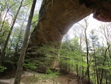 South Arch
 The Twin Arches are 2 large arches, North Arch and South Arch, situated next to each other. The South Arch is the bigger of the two at over 100' tall while the North Arch is just over 60' tall. The cool thing about the North Arch is the tunnel. Two awesome arches that are well worth checking out!
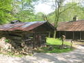
After spending some time admiring the arches I continued down to Charit Creek where I planned to camp. "The Island" is a small bit of land in the middle of the creek that is an established campsite. We were able to stay there last year on our section hike of the Sheltowee. I was hoping I might get to stay there this trip but, figured there was a good chance it would be occupied since the weather was so nice. I was right...It was tent city. There was barely a spec of dirt left uncovered. I went back to the Charit Creek Lodge to talk to Gregg and have a Coke (and see Booger - the dog). The lodge was booked full for weekend and they were getting ready for dinner - pork tenderloin.
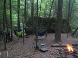
I chatted with Gregg for a minute and he said there was a nice area a few tenths of a mile past The Island. I finished my Coke and went in search of a nice spot to hang. I found a very well used site where the road crossed the creek but found a nicer spot more out of sight near the turn off to go back to Jake's Place.
I set up camp, gathered some firewood and started dinner. Dinner for the night was Pork Al pastor & rice with tortillas and Snickers bar for dessert.
My camp was right along the creek where a tree had fallen causing a small cascade (read nature's music). I always look for wet campsites because I like to be able to rehydrate all night and the sound is very relaxing for me. Plus, it drowns out some of the many sounds in the backcountry at night.
I read some while I enjoyed the fire and when the daylight faded I moved to my hammock and continued reading by the light of my Luci Light. It stayed light until around 8:30 by which time I was already tired. I finished the chapter I was on and dozed off.
I hung my tarp but never took it out of the sleeves. I woke up around 3:00 to a moonlight sky. Love to be able to sleep without cover.
After spending some time admiring the arches I continued down to Charit Creek where I planned to camp. "The Island" is a small bit of land in the middle of the creek that is an established campsite. We were able to stay there last year on our section hike of the Sheltowee. I was hoping I might get to stay there this trip but, figured there was a good chance it would be occupied since the weather was so nice. I was right...It was tent city. There was barely a spec of dirt left uncovered. I went back to the Charit Creek Lodge to talk to Gregg and have a Coke (and see Booger - the dog). The lodge was booked full for weekend and they were getting ready for dinner - pork tenderloin.
I chatted with Gregg for a minute and he said there was a nice area a few tenths of a mile past The Island. I finished my Coke and went in search of a nice spot to hang. I found a very well used site where the road crossed the creek but found a nicer spot more out of sight near the turn off to go back to Jake's Place.
I set up camp, gathered some firewood and started dinner. Dinner for the night was Pork Al pastor & rice with tortillas and Snickers bar for dessert.
My camp was right along the creek where a tree had fallen causing a small cascade (read nature's music). I always look for wet campsites because I like to be able to rehydrate all night and the sound is very relaxing for me. Plus, it drowns out some of the many sounds in the backcountry at night.
I read some while I enjoyed the fire and when the daylight faded I moved to my hammock and continued reading by the light of my Luci Light. It stayed light until around 8:30 by which time I was already tired. I finished the chapter I was on and dozed off.
I hung my tarp but never took it out of the sleeves. I woke up around 3:00 to a moonlight sky. Love to be able to sleep without cover.
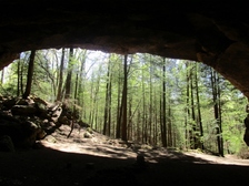 Indian Rock House
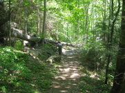
 Day 2: I got up around 6:30 and started breaking camp. My plan was to hike early in the morning and stop mid morning for breakfast. I continued south toward Laurel Fork Creek. But, first I would have to hike up from Station Camp Creek before going back down to Laurel Creek. That being the case, my morning kicked off with a hike uphill on the gravel road/horse trail - Charit Creek Horse Trail. This is a short split off the Sheltowee for horses since that part of the Sheltowee is not passable on horse. It wasn't long before I started back down on the way to Laurel Fork Creek. Once to the creek I found a nice spot to stop and fix a salted carmel latte and oatmeal. While eating breakfast 4 backpackers came by doing the same route as me in the opposite direction, except they started at the Middle Creek trailhead. Counting the creek crossing I was sitting at they said they counted 30 water crossings. I have the book "Hiking the Big South Fork" and it claims 18 water fords. I counted them too and I counted A LOT!
Speaking of "Hiking the Big South Fork" - to be honest I was a bit anxious about doing this hike solo. I knew this area of the Big South Fork was fairly remote and the book described the Laurel Fork Creek Trail as poorly marked and difficult to navigate. I agree that is not marked the best but, I only questioned the route a couple times, mainly because the trail name never appeared on any signs. Overall, if you have a decent sense of direction and pay attention to your map you shouldn't have any issues. Plus, knowing the trail generally follows the creek you know if you get too far away from the creek something may not be right.
The Laurel Fork Creek Trail zig-zags back & forth across the creek countless times. I was able to make all the fords but one without getting water over my boots and that one time was because I was rushing and slipped. If you pick your lines and take your time you should be able to make most, if not all, of the fords without getting wet or having to take your shoes off. I found the trail to be a lot fun with the water crossings and the remoteness. It was a welcome change from day one when I saw lots of people. I only saw 2 groups of people on the Laurel Fork Creek Trail. I take that back, I also saw two people on horseback on the hiking only trail. She proclaimed her innocence to me by saying she must have made a wrong turn and was lost. I thought yes, you made a wrong turn past the barricade and no horses sign. I'm not sure why she was pleading her case...I'm not a park ranger. I guess it was guilt. She clearly was not the only one that disregarded foot traffic only restriction.
Just after leaving the Sheltowee I stopped to make some adjustments. Just as I started back I heard something four legged running up behind me. Just as I turned I see a German Shepherd run past me. I waited a minute to see what his intentions were and to see if anyone was coming after him. It was clear that he was just there to have a good time and I didn't hear or see anyone. So, it seemed I had an new trail partner and we continued on. I later stopped for a break and to again see if I heard anyone looking for my trail buddy. Then I heard some voices as a group of guys caught up and I found Gunnar's people. We all hiked together for awhile and Gunnar and I pulled ahead. Then as quickly as Gunnar showed up he was gone. I stopped at the split for Bandy Creek Campground as I knew that was where Gunnar & his group were headed. I didn't want Gunnar following me and getting split from them. I rested for while and had some water and snacks until I saw them pass. Then I continued on. Shortly after I came to the first area I really wasn't sure about. Based upon the map and where I was last certain to be on said map I thought I was at the Salt Pine Ridge Trail. But, there were no trail names or identifiers. I knew I needed to be going northwest so I continued in that direction. About another mile and half would be my next marker and trail intersection with Yellow Cliff Trail. Again, no trail names or identifiers but still fairly confident I was on track. I stopped here to filter more water and have lunch. There's a well established campsite where Laurel Fork Creek Trail leaves the Yellow Cliff Trail.
I continued my endless water fords before starting the climb away from Laurel Fork Creek. There's an established campsite near the end before you climb up. I think there is one more water crossing after that campsite and that is the last opportunity for water. I knew by reading the map I had to be getting close to the last water source so, I filled up at the campsite and took a short break.
As you climb up from the creek there are steps carved into a large rock that you climb up. I soon came to the intersection with the Slave Falls Loop Trail and not far past that I made it to Indian Rock House. This is a large rock house that would be a great place to take a break and cool off or get out of the weather. Not far from the Sawmill trailhead at this point and was making better time than I expected. I knew I should be back at the car around 3:00. When I hit Fork Ridge Rd. I knew the car was just around the bend. And, just before 3:00 I was back to the car.
I really enjoyed this trip. I thought I might have the timing off for wildflowers but was hoping to see the trees blooming, at least Dogwoods. I was able to catch the trees and flowers!
There were a lot of cool things to see along this route and I did not find it overly challenging. Definitely a good one night loop. I think you could add some to this to also make a nice 2 night route, which I may do in the future. If you're hiking in the area I would recommend seeing the Twin Arches. I wouldn't go far out of the way to see Slave Falls though. And, I really enjoyed the Laurel Fork Creek Trail. I found the water crossings kept it interesting and it felt like it had a remote feel to it.
Note that if you go to this area cell signal is very limited. I lost signal just outside Monticello. So, make your necessary contacts before you arrive.
Honorable Mentions: I like to have sunglasses and wanted amber lenses rather than dark lenses. But, didn't want to spend a lot in case I break them or lose them. I found a pair of amber polarized lenses made by Ugly Stik. I found them at Meijer on sale buy a pair get a pair for $1. I got 2 pair for $20.99.
I also picked up 6 neck buffs on Amazon and took one on this trip. I found it nice because it wasn't cold enough for a beanie or balaclava and I could use it just as an ear muff and the the heat escape while I hiked in the morning.
Dishonorably Discharged: Nothing. I used everything I brought except my first aid kit (thankfully!), rain poncho and some spare cordage.
 RSS Feed
