The Turtle Strikes Again
Just the Facts
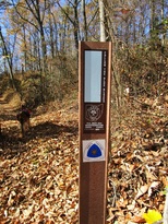
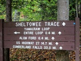
Location: Sheltowee Trace - Daniel Boone National Forest, KY
General Rules and Regulations: Camping is not allowed in the developed areas. Camping is allowed near the developed parking areas when the campsite is at least 200 feet from the edge of the parking area and IS NOT VISIBLE from the parking area. As of May 1, 1991, the following are considered developed areas: Yahoo Falls, Alum Ford, Yamacraw, Blue Heron Overlooks, Blue Heron and access areas along river, East Rim Overlook, Leatherwood Ford, West Entrance, Charit Creek, Twin Arches, Burnt Mill Bridge, Peters Bridge, Bear Creek Overlook, Brewster Bridge, and Honey Creek Overlook.
Camping is strictly prohibited within 25 feet of any cave, cemetery, grave site, historic site/structure, rock shelter, rim of the gorge, trail, roadway, or any other specified location identified by a "No Camping" sign.
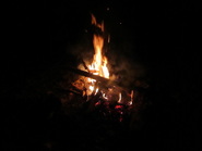
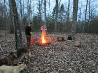
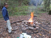
Campfires are allowed unless condition dictate otherwise.
Backcountry permits are required within the Big South Fork (not required in the Daniel Boone National Forest in this section).
See the National Park Service website for more details.
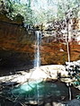
Trip Highlights: 1 day; temps ranged from low 50s to upper 60s; approximately 6 miles. The Dogwoods were blooming as well as some spring flowers and plenty of water.
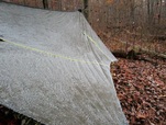
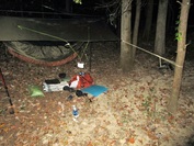
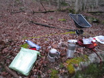
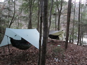
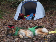
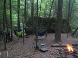
Shelter: Warbonnet Black Bird hammock, DYI Synthetic Underquilt, Underground Quilts top quilt, Warbonnet Mamajamba Tarp w/DIY Door Kit
Wildlife: One drowned toad
Miscellaneous: http://www.sheltoweetrace.org/
The Sheltowee Trace is Kentucky's long trail. The southern terminus has moved farther south a few times and is currently at the Burnt Mill Bridge in Allardt, TN. The trail runs 323 miles to the northern terminus located off KY 377 at the northern end of the Daniel Boone National Forest (north of Morehead, KY).
Location: Sheltowee Trace - Daniel Boone National Forest, KY
General Rules and Regulations: Camping is not allowed in the developed areas. Camping is allowed near the developed parking areas when the campsite is at least 200 feet from the edge of the parking area and IS NOT VISIBLE from the parking area. As of May 1, 1991, the following are considered developed areas: Yahoo Falls, Alum Ford, Yamacraw, Blue Heron Overlooks, Blue Heron and access areas along river, East Rim Overlook, Leatherwood Ford, West Entrance, Charit Creek, Twin Arches, Burnt Mill Bridge, Peters Bridge, Bear Creek Overlook, Brewster Bridge, and Honey Creek Overlook.
Camping is strictly prohibited within 25 feet of any cave, cemetery, grave site, historic site/structure, rock shelter, rim of the gorge, trail, roadway, or any other specified location identified by a "No Camping" sign.
Campfires are allowed unless condition dictate otherwise.
Backcountry permits are required within the Big South Fork (not required in the Daniel Boone National Forest in this section).
See the National Park Service website for more details.
Trip Highlights: 1 day; temps ranged from low 50s to upper 60s; approximately 6 miles. The Dogwoods were blooming as well as some spring flowers and plenty of water.
Shelter: Warbonnet Black Bird hammock, DYI Synthetic Underquilt, Underground Quilts top quilt, Warbonnet Mamajamba Tarp w/DIY Door Kit
Wildlife: One drowned toad
Miscellaneous: http://www.sheltoweetrace.org/
The Sheltowee Trace is Kentucky's long trail. The southern terminus has moved farther south a few times and is currently at the Burnt Mill Bridge in Allardt, TN. The trail runs 323 miles to the northern terminus located off KY 377 at the northern end of the Daniel Boone National Forest (north of Morehead, KY).
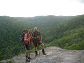
This was numero tres of our section hike of the Sheltowee Trace. Our plan was to start in Whitley and hike north to around Livingston. Our first section of the Sheltowee was almost perfect aside from a couple navigation snafus. Our second section was cut short after a couple days because of dry conditions that left all the water sources dried up and the fire danger at the extreme level. We were looking forward to the third attempt and redeeming the prior bust as well as a chance to unplug from the chaos of the rat race. The good news is that a lack of water would not be an issue.
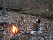
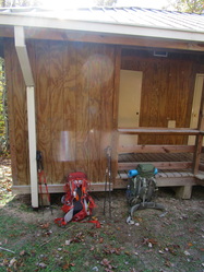
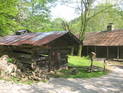
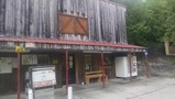
We once again rendezvoused at "Spark Outfitters" to begin our trip. I stopped at Milton's on the way in for the customary milkshake as a late night snack. Kyle loaded up on calories with some Kentucky round steak and a hot fudge cake, washed down with a milkshake.
We both arrived late in the evening in a steady rain and went to bed shortly after saying hello, falling asleep to the soothing pitter patter of the rain on the tin roof.
Day 1 (Sat):
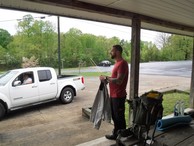
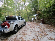
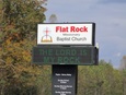
I barely got up in enough time to shower, wake Kyle and go back to bed for an hour, still listening to the rain beat on the roof, before we smelled bacon & sausage - Kyle wasn't excited with my timing. While we ate breakfast we pulled up the forecast which looked more like a child's painting full of colorful patterns of green, orange & red. The forecast was calling for a break in the heavy rain around Noon and around 10:00 the rain mostly let up. With the break in the weather we scrambled to load up and head off to Flat Rock Church where we left off last time. Once at the church we anxiously waited for words of wisdom from Bobby as we sorted our gear. I think our words of encouragement were something along the lines of "y'all are gonna get wet". With those reassuring words we headed north on another hunt for the "Big Turtle".
We both arrived late in the evening in a steady rain and went to bed shortly after saying hello, falling asleep to the soothing pitter patter of the rain on the tin roof.
Day 1 (Sat):
I barely got up in enough time to shower, wake Kyle and go back to bed for an hour, still listening to the rain beat on the roof, before we smelled bacon & sausage - Kyle wasn't excited with my timing. While we ate breakfast we pulled up the forecast which looked more like a child's painting full of colorful patterns of green, orange & red. The forecast was calling for a break in the heavy rain around Noon and around 10:00 the rain mostly let up. With the break in the weather we scrambled to load up and head off to Flat Rock Church where we left off last time. Once at the church we anxiously waited for words of wisdom from Bobby as we sorted our gear. I think our words of encouragement were something along the lines of "y'all are gonna get wet". With those reassuring words we headed north on another hunt for the "Big Turtle".
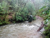
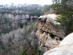
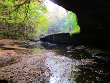
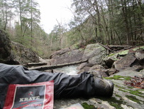
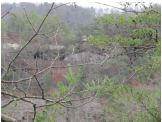
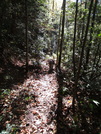
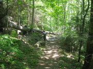
The trail north of US-27 starts with a brief road walk before cutting off into the woods paralleling US-27 for a bit. The trail soon heads away from the sounds of traffic and begins following Barren Fork Creek. We would cross Barren Fork and other side streams many times. These streams were all filled to capacity, or beyond, each requiring strategic navigation or risk plunging in for a swim. In an effort to keep our boots dry we made several crossings barefoot, each time stopping ahead to strip our shoes & socks before dipping a toe into the cold water. Once to the other side we carefully washed and dried our feet before lacing back up. This got more challenging as the rain moved back in and we tried to dry wet feet in the rain. Each time we stopped to shed our boots and carefully navigate the water and slip our feet back into our boots we were greeted with warm dry boots and reminded it was worth the effort.
With each stream crossing the water seemed to get progressively higher and faster. As we hiked along the creek it began to sound more like a river than a small stream. We began questioning at what point will we make a crossing that we won't be able to return from. We wanted to stop early and set up camp but we also wanted to make as many water crossings as we could before the water rose higher the next morning and cool morning temperatures would make the crossings even worse. After crossing Barren Fork near Taylor Ridge Rd. we hiked about another mile when we hit our limit. The trail dropped off into deep swift water and followed the creek around a bend before exiting out of the water. We looked around up a smaller stream feeding Barren Fork and couldn't find a good spot to cross. This would be where we drew the line knowing that this crossing had the potential to at best get us wet above our waist and at worst, well...
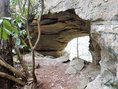
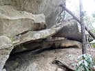
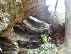
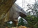
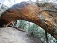
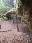
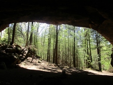
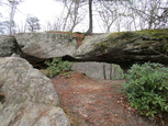
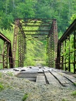
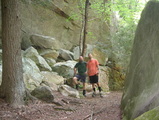
We took cover under a nearby rock shelter and had a snack before backtracking to Taylor Ridge Rd. We headed up Taylor Ridge toward Sand Hill Gap where we called "Spark Outfitters" for extraction.
With each stream crossing the water seemed to get progressively higher and faster. As we hiked along the creek it began to sound more like a river than a small stream. We began questioning at what point will we make a crossing that we won't be able to return from. We wanted to stop early and set up camp but we also wanted to make as many water crossings as we could before the water rose higher the next morning and cool morning temperatures would make the crossings even worse. After crossing Barren Fork near Taylor Ridge Rd. we hiked about another mile when we hit our limit. The trail dropped off into deep swift water and followed the creek around a bend before exiting out of the water. We looked around up a smaller stream feeding Barren Fork and couldn't find a good spot to cross. This would be where we drew the line knowing that this crossing had the potential to at best get us wet above our waist and at worst, well...
We took cover under a nearby rock shelter and had a snack before backtracking to Taylor Ridge Rd. We headed up Taylor Ridge toward Sand Hill Gap where we called "Spark Outfitters" for extraction.
Day 2 (Sun):
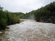
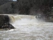
We spent Sunday driving around to confirm exactly where Bobby could drop us off past the swollen Barren Fork Creek. We then drove to Cumberland Falls to see just how angry the river was - And she was a hateful ole hag! Back at "Spark Outfitters" we tuned to the Weather Channel to see reports of the Cumberland River being 4 1/2 to 5 feet above flood stage and not expected to be below flood stage again until Thursday. We knew there was a high water route north of the falls but, the trail followed the banks of the Cumberland south of the falls as well. Knowing that a good portion of the trail would certainly be under water and that any stream crossings would be challenging we pulled the plug on this trip. And with that, the score is Squids - 1, Turtle - 2!
We later learned that that Cumberland Falls State Park had closed all trails, as such the Sheltowee was also closed, confirming our decision to bag this trip was a good one. Our last two attempts were conflicting extremes - one with no water and the other with too much water. This turtle is taking on the personality of a snapping turtle!
Honorable Mentions: I've been trying to get into trail running (more like crawling) and through that I found Drymax socks. I've been trying to make an effort to take better care of my feet on the trail and thought I would give these a try as they have pretty good recommendations. Granted, I only had one day in them but, they did good for that one day and I didn't use sock liners. I'll give them another go next time.
Honorably Discharged: Too short of a trip to name anything.
Dishonorably Discharged: Flooding!
Honorably Discharged: Too short of a trip to name anything.
Dishonorably Discharged: Flooding!
 RSS Feed
