Gone To The Dogs
Just the Facts
Location: Sheltowee Trace - Daniel Boone National Forest, KY
General Rules and Regulations: Camping is not allowed in the developed areas. Camping is allowed near the developed parking areas when the campsite is at least 200 feet from the edge of the parking area and IS NOT VISIBLE from the parking area. As of May 1, 1991, the following are considered developed areas: Yahoo Falls, Alum Ford, Yamacraw, Blue Heron Overlooks, Blue Heron and access areas along river, East Rim Overlook, Leatherwood Ford, West Entrance, Charit Creek, Twin Arches, Burnt Mill Bridge, Peters Bridge, Bear Creek Overlook, Brewster Bridge, and Honey Creek Overlook.
Camping is strictly prohibited within 25 feet of any cave, cemetery, grave site, historic site/structure, rock shelter, rim of the gorge, trail, roadway, or any other specified location identified by a "No Camping" sign.
Campfires are allowed unless condition dictate otherwise.
Backcountry permits are required within the Big South Fork (not required in the Daniel Boone National Forest in this section).
See the National Park Service website for more details.
Trip Highlights: 3 days/2nights; temps ranged from low 50s to upper 70s; approximately 35 miles. Spring flowers blanketed the landscape and trees were budding & starting leaf out.
Shelter: Warbonnet Black Bird hammock, DYI Underquilt, Underground Quilts top quilt, Warbonnet Mamajamba Tarp w/DIY Door Kit
Wildlife: Whitetail deer & birds.
Miscellaneous: http://www.sheltoweetrace.org/
The Sheltowee Trace is Kentucky's long trail. The southern terminus has moved farther south a few times and is currently at the Burnt Mill Bridge in Allardt, TN. The trail runs 323 miles to the northern terminus located off KY 377 at the northern end of the Daniel Boone National Forest (north of Morehead, KY).
I'm not sure how much longer I'll be able to say the trail is 323 miles long with the southern terminus being located at the Burnt Mill Bridge. Just recently the STA announced that the southern terminus will be extended to Frozen Head State Park in Morgan County, TN, near Wartburg.
Me made our rendezvous at Kyle's aunt & uncle's again. The plan would be for Spark to drop us off at the Turkey Foot Campground and pick us up along KY-1036 on Sunday. The weather forecast called for rain Friday morning and then Sunday morning. But, overall the forecast wasn't too hateful.
Day 1 (Friday)
We awoke to rain on Friday morning as we sorted things to prepare for the drive to the Turkey Foot Campground. We stopped for a quick breakfast at Arby's and then on toward McKee. No real words of wisdom or encouragement from Spark this round. I think he gave us the last weather report and was off.
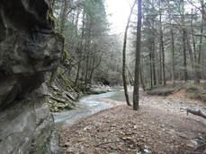
After a pit stop in the campground and a short chat with a fisherman we were walking north around 11:30. The trail leaves the campground running parallel to Elsman Fork Rd. before dropping down to War Fork Creek. We stopped here to relax and enjoy the creek while we had lunch. This is one of the places the stream goes underground and then comes back out. Upstream was a dry creek bed but where the trail crosses, the water is flowing out of a cave/hole in the hillside. This is a place to return and explore when there's more time and a bit warmer.
We hiked about 6 miles after lunch until we hit the pavement near Arvel. We had been seeing pink ribbons since we left the campground. We guessed these to be part of a trail run and once at the road there were arrows and WH painted on the road - We were pretty sure that these were ribbons from the War Hammer trail run.
Walking KY-587 north we crossed into Lee County where we were greeted by the first of many dogs this trip. After leaving KY-587 we picked up trail again. We hiked a little less than a mile before we picked a spot to camp for the night putting us at about 10 miles for the day. We got camp set up and started gathering firewood and cooking dinner. After dinner we had a small fire and enjoyed s'mores before heading to bed.
Me made our rendezvous at Kyle's aunt & uncle's again. The plan would be for Spark to drop us off at the Turkey Foot Campground and pick us up along KY-1036 on Sunday. The weather forecast called for rain Friday morning and then Sunday morning. But, overall the forecast wasn't too hateful.
Day 1 (Friday)
We awoke to rain on Friday morning as we sorted things to prepare for the drive to the Turkey Foot Campground. We stopped for a quick breakfast at Arby's and then on toward McKee. No real words of wisdom or encouragement from Spark this round. I think he gave us the last weather report and was off.
After a pit stop in the campground and a short chat with a fisherman we were walking north around 11:30. The trail leaves the campground running parallel to Elsman Fork Rd. before dropping down to War Fork Creek. We stopped here to relax and enjoy the creek while we had lunch. This is one of the places the stream goes underground and then comes back out. Upstream was a dry creek bed but where the trail crosses, the water is flowing out of a cave/hole in the hillside. This is a place to return and explore when there's more time and a bit warmer.
We hiked about 6 miles after lunch until we hit the pavement near Arvel. We had been seeing pink ribbons since we left the campground. We guessed these to be part of a trail run and once at the road there were arrows and WH painted on the road - We were pretty sure that these were ribbons from the War Hammer trail run.
Walking KY-587 north we crossed into Lee County where we were greeted by the first of many dogs this trip. After leaving KY-587 we picked up trail again. We hiked a little less than a mile before we picked a spot to camp for the night putting us at about 10 miles for the day. We got camp set up and started gathering firewood and cooking dinner. After dinner we had a small fire and enjoyed s'mores before heading to bed.
Day 2 (Saturday)
We left camp around 9:00 to climb up to a forest road and east to Todd Rd. We were back on pavement around lunch time and stopped at the Cressmont Baptist Church to eat. We were fueled up and ready to hit KY-399. We crossed Sturgeon Creek before heading up KY-399 and across the Kentucky River into Heidelberg. Heidelberg is a rather inconspicuous town but, the city park seemed like the place to be. The parking lot of the park was oddly full. It turns out that is where the participants of the STA hiker challenge had staged their cars for the end of that section.
The Sheltowee Trace follows KY-399 for about 10 miles where it picks up KY-52 for about a 1/2 mile. That makes for about a 15 mile road walk. And, the climb out of Heidelberg SUCKED...It felt like it went up hill for miles!
Once we finally climbed the long hill out of Heidelberg we passed the Quillan Cemetery where I was greeted with one of the many unrestrained and uncontrolled dogs. This little ankle biter tried three time to bite me despite kicks coming it's way. I could hear a woman yelling at all the dogs and another woman to get the dogs...Both the dogs and the other woman ignored the calls to stop. The talk went something like this:
Female 1: "You better get your dogs before they bite someone."
Female 2: "I don't care!"
Female 1: "You will when someone sues you!"
Female 2: "How they gonna do that? They're walking on the road!"
Me: Shaking my head
Luckily, the lil monster didn't know what it was doing or couldn't get it's mouth open enough to get a good bite through my compression sleeves.
We passed Mark from England who was thru-hiking southbound. He warned us about another dog just before KY-52 that bit him - He had a nasty little bite on his calf. Never what you want but, even worse when you're trying to put in miles everyday. Compounded by the fact that dogs aren't exactly well cared for in this area. Speaking of which...It seems like everyone seems to want a dog and most of them have no business having one, let alone multiple.
Check out Mark on Instagram as goingforalittlewalk.
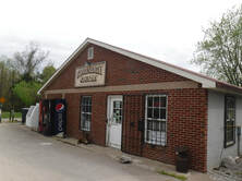
We made a stop at the Conveniently Country Store and got some water and an Ale 8 before continuing our march on KY-399. We saw a gentleman just before the Bear Track fire station and he offered us a cold bottle of water and let us know it was bout 1 mile to KY-52. We thanked him for the water and prepared ourselves to deal with the aggressive dog and marched into battle. Thankfully, we passed the suspected house without incident.
We finally made it to New Virginia Rd. which is where we needed to be in order to find a camp. We continued on New Virginia Rd. with our eyes peeled for the first suitable place to string up our hammocks. We spotted an area without a lot of undergrowth and away from the road a ways and quickly made camp. After a 20 mile day with all the road walking we were both spent. We ate and went straight to our hammocks.
The weather forecast wasn't calling for rain until late morning on Sunday. But, we were treated to rounds of thunderstorms and periods of heavy rain throughout the night.
We left camp around 9:00 to climb up to a forest road and east to Todd Rd. We were back on pavement around lunch time and stopped at the Cressmont Baptist Church to eat. We were fueled up and ready to hit KY-399. We crossed Sturgeon Creek before heading up KY-399 and across the Kentucky River into Heidelberg. Heidelberg is a rather inconspicuous town but, the city park seemed like the place to be. The parking lot of the park was oddly full. It turns out that is where the participants of the STA hiker challenge had staged their cars for the end of that section.
The Sheltowee Trace follows KY-399 for about 10 miles where it picks up KY-52 for about a 1/2 mile. That makes for about a 15 mile road walk. And, the climb out of Heidelberg SUCKED...It felt like it went up hill for miles!
Once we finally climbed the long hill out of Heidelberg we passed the Quillan Cemetery where I was greeted with one of the many unrestrained and uncontrolled dogs. This little ankle biter tried three time to bite me despite kicks coming it's way. I could hear a woman yelling at all the dogs and another woman to get the dogs...Both the dogs and the other woman ignored the calls to stop. The talk went something like this:
Female 1: "You better get your dogs before they bite someone."
Female 2: "I don't care!"
Female 1: "You will when someone sues you!"
Female 2: "How they gonna do that? They're walking on the road!"
Me: Shaking my head
Luckily, the lil monster didn't know what it was doing or couldn't get it's mouth open enough to get a good bite through my compression sleeves.
We passed Mark from England who was thru-hiking southbound. He warned us about another dog just before KY-52 that bit him - He had a nasty little bite on his calf. Never what you want but, even worse when you're trying to put in miles everyday. Compounded by the fact that dogs aren't exactly well cared for in this area. Speaking of which...It seems like everyone seems to want a dog and most of them have no business having one, let alone multiple.
Check out Mark on Instagram as goingforalittlewalk.
We made a stop at the Conveniently Country Store and got some water and an Ale 8 before continuing our march on KY-399. We saw a gentleman just before the Bear Track fire station and he offered us a cold bottle of water and let us know it was bout 1 mile to KY-52. We thanked him for the water and prepared ourselves to deal with the aggressive dog and marched into battle. Thankfully, we passed the suspected house without incident.
We finally made it to New Virginia Rd. which is where we needed to be in order to find a camp. We continued on New Virginia Rd. with our eyes peeled for the first suitable place to string up our hammocks. We spotted an area without a lot of undergrowth and away from the road a ways and quickly made camp. After a 20 mile day with all the road walking we were both spent. We ate and went straight to our hammocks.
The weather forecast wasn't calling for rain until late morning on Sunday. But, we were treated to rounds of thunderstorms and periods of heavy rain throughout the night.
Day 3 (Sunday)
A quick breakfast and we packed up in the rain to head to our evac spot. We were on trail just before 8:30 and started passing hikers. After passing the first 5 we said that's more people than we've seen in over 200 miles. When we hit the next group we asked if they were part of the hiker challenge and they confirmed that they were in fact part of the challenge. We passed several more as we made our way toward KY-1036.
For more information on the STA Hiker Challenge check out the STA web page - CLICK HERE.
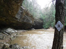
When we got to Sinking Creek we got a tip on the hot line to cross without going in waist deep. We got across with no drama and passed along the tip to others as they passed. It wasn't long before we were to KY-1036 and shortly greeted by more unwelcoming dogs. We kept them at bay with our trekking poles and continued on our way. We made it to Smyth Cemetery Rd. around 10:30 and thankfully the rain stopped just as we got there. We sat and ate snacks as the sun peeked through and we waited on Spark. Spark rolled up around 11:00 to take us back for burgers and a shower!
A quick breakfast and we packed up in the rain to head to our evac spot. We were on trail just before 8:30 and started passing hikers. After passing the first 5 we said that's more people than we've seen in over 200 miles. When we hit the next group we asked if they were part of the hiker challenge and they confirmed that they were in fact part of the challenge. We passed several more as we made our way toward KY-1036.
For more information on the STA Hiker Challenge check out the STA web page - CLICK HERE.
When we got to Sinking Creek we got a tip on the hot line to cross without going in waist deep. We got across with no drama and passed along the tip to others as they passed. It wasn't long before we were to KY-1036 and shortly greeted by more unwelcoming dogs. We kept them at bay with our trekking poles and continued on our way. We made it to Smyth Cemetery Rd. around 10:30 and thankfully the rain stopped just as we got there. We sat and ate snacks as the sun peeked through and we waited on Spark. Spark rolled up around 11:00 to take us back for burgers and a shower!
This section was a bit of love/hate. The trail sections were great and the road sections were rough. We thought the road sections would be an opportunity to bang out miles...We were wrong. I think our pace was about the same, if not slower, on the road.
We are now within 100 miles of the northern terminus and completing the trail (unless they get the new trail in before we finish). Our next section will take us through the Natural Bridge State Park and Red River Gorge offering lots to see.
We are now within 100 miles of the northern terminus and completing the trail (unless they get the new trail in before we finish). Our next section will take us through the Natural Bridge State Park and Red River Gorge offering lots to see.
 RSS Feed
